Tocht Andere activiteiten Frévent - Nord - Pas-de-Calais - Ligne 305 - Saint-Roch - Frévent - Photo

Nord - Pas-de-Calais - Ligne 305 - Saint-Roch - Frévent

 mich54
mich54

Gebruiker

© OpenStreetMap contributors
Lengte
Lengte
11 km
Max. hoogte
Max. hoogte
158 m
Positief hoogteverschil
119 m
Km-Effort
Km-Effort  
12,4 km
Min. hoogte
Min. hoogte
75 m
Negatief hoogteverschil
60 m
Boucle
Boucle
Neen
Datum van aanmaak :
2016-11-04 00:00:00.0
Laatste wijziging :
2016-11-04 00:00:00.0

(0 Bericht)

Andere activiteiten
Andere activiteiten
5m
Moeilijkheid : Onbekend

Scan deze QR-code om de tocht te openen in de SityTrail-applicatie

Gratisgps-wandelapplicatie

Logo SityTrail SityTrail

IGN / Geografische instituten

SityTrail uit de App Store downloaden SityTrail uit Google Play downloaden

Logo SityTrail SityTrail World

De wereld gaat voor u open

SityTrail uit de App Store downloaden SityTrail uit Google Play downloaden SityTrail op Huawei AppGallery downloaden

Over ons

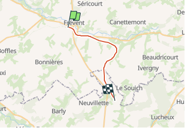
Tocht Andere activiteiten van 11 km beschikbaar op Hauts-de-France, Pas-de-Calais, Frévent. Deze tocht wordt voorgesteld door mich54.

Beschrijving

Section de Bouquemaison à Frévent.
La ligne de Saint-Roch à Frévent est une ligne de chemin de fer non électrifiée à voie unique qui relie la gare de Saint-Roch (Somme) à celle de Frévent sur la ligne de Fives à Abbeville. Elle est déposée sur une partie de son parcours, entre Frévent et Doullens.(Source Wikipédia)

Hoogteprofiel

Plaatsbepaling

Land:
France
Regio :
Hauts-de-France
Departement/Provincie :
Pas-de-Calais
Gemeente :
Frévent
Locatie:
Unknown
Vertrek:(Dec)
Vertrek:(UTM)
449034 ; 5569345 (31U) N.

Wandeltochten in de omgeving

Tocht Stappen Boubers-sur-Canche - 7 km autour de Boubers sur Canche - Photo
Stappen
tracegps

Stappen

Gemakkelijk
Boubers-sur-Canche, Hauts-de-France, Pas-de-Calais, France
6,8 km | 7,9 km-effort
1h 40min
Ja
Tocht Stappen Ligny-sur-Canche - LIGNY SUR CANCHE - Le fond de Boubers - Photo
Stappen
temmichel

Stappen

Moeilijk
Ligny-sur-Canche, Hauts-de-France, Pas-de-Calais, France
10,7 km | 12,7 km-effort
2h 52min
Ja
Tocht Te voet Bonnières - BONNIERES (62) - Les éoliennes - Photo
Te voet
temmichel

Te voet

Gemakkelijk
Bonnières, Hauts-de-France, Pas-de-Calais, France
15,2 km | 16,9 km-effort
3h 50min
Ja
Tocht Stappen Frévent - FREVENT  - Photo
Stappen
dehemjacques

Stappen

Medium
Frévent, Hauts-de-France, Pas-de-Calais, France
27 km | 31 km-effort
6h 42min
Ja
Tocht Stappen Frévent - Rando Frevent 16 km - Photo
Stappen
alainchti62

Stappen

Moeilijk
Frévent, Hauts-de-France, Pas-de-Calais, France
15,9 km | 18,4 km-effort
4h 11min
Ja
Tocht Stappen Frévent - Frévent (3) 23.5Kms Dén P 319m - Photo
Stappen
alain62rando

Stappen

Zeer moeilijk
Frévent, Hauts-de-France, Pas-de-Calais, France
24 km | 28 km-effort
6h 4min
Ja


Sluiten
Mijn abonnementen