Tocht Stappen Saint-Cyprien - RP66 ST CYPRIEN CANET Villages des pêcheurs le 24.11.2016  - Photo

RP66 ST CYPRIEN CANET Villages des pêcheurs le 24.11.2016

 jeff66
jeff66

Gebruiker

© OpenStreetMap contributors
Lengte
Lengte
11,6 km
Max. hoogte
Max. hoogte
4 m
Positief hoogteverschil
26 m
Km-Effort
Km-Effort  
12 km
Min. hoogte
Min. hoogte
-4 m
Negatief hoogteverschil
26 m
Boucle
Boucle
Ja
Datum van aanmaak :
2016-11-25 00:00:00.0
Laatste wijziging :
2016-11-25 00:00:00.0

(1 Bericht)

Stappen
Stappen
2h21
Moeilijkheid : Gemakkelijk

Scan deze QR-code om de tocht te openen in de SityTrail-applicatie

Gratisgps-wandelapplicatie

Logo SityTrail SityTrail

IGN / Geografische instituten

SityTrail uit de App Store downloaden SityTrail uit Google Play downloaden

Logo SityTrail SityTrail World

De wereld gaat voor u open

SityTrail uit de App Store downloaden SityTrail uit Google Play downloaden SityTrail op Huawei AppGallery downloaden

Over ons

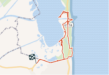
Tocht Stappen van 11,6 km beschikbaar op Occitanië, Pyrénées-Orientales, Saint-Cyprien. Deze tocht wordt voorgesteld door jeff66.

Beschrijving

RP66 ST CYPRIEN CANET Villages des pêcheurs le 24.11.2016

Hoogteprofiel

Plaatsbepaling

Land:
France
Regio :
Occitanië
Departement/Provincie :
Pyrénées-Orientales
Gemeente :
Saint-Cyprien
Locatie:
Unknown
Vertrek:(Dec)
Vertrek:(UTM)
501222 ; 4720607 (31T) N.

Opmerkingen

Gelieve in te loggen om een commentaar of een beoordeling achter te laten


CASTELNOU


Wandeltochten in de omgeving

Tocht Stappen Saint-Cyprien - SAINT-CYPRIEN 66 - front de mer - les CAPELLANS - Photo
Stappen
jeff66

Stappen

Gemakkelijk
(2)
Saint-Cyprien, Occitanië, Pyrénées-Orientales, France
9,9 km | 10,3 km-effort
2h 11min
Ja
Tocht Paard Saint-Cyprien - bocal du Tech - Photo
Paard
sandymocko

Paard

Medium
(1)
Saint-Cyprien, Occitanië, Pyrénées-Orientales, France
17 km | 17,7 km-effort
3h 20min
Ja
Tocht Stappen Saleilles - 66 SALEILLES - St-NAZAIRE, entre FOSSEILLE et REART - Photo
Stappen
jeff66

Stappen

Gemakkelijk
(1)
Saleilles, Occitanië, Pyrénées-Orientales, France
7,3 km | 7,7 km-effort
1h 8min
Ja
Tocht Stappen Saint-Cyprien - 66 SAINT-CYPRIEN - ALENYA - LATOUR-BAS-ELNE - de berges en berges  - Photo
Stappen
jeff66

Stappen

Medium
Saint-Cyprien, Occitanië, Pyrénées-Orientales, France
7,9 km | 8,3 km-effort
1h 16min
Ja
Tocht Stappen Saint-Nazaire - 66 SAINT-NAZAIRE - CABESTANY promenade dans le vignoble de galets - Photo
Stappen
jeff66

Stappen

Medium
Saint-Nazaire, Occitanië, Pyrénées-Orientales, France
9 km | 9,9 km-effort
1h 29min
Ja
Tocht Stappen Canet-en-Roussillon - CANET-EN-ROUSSILLON 66 - entre mer, plage, dunes et étang - SAINT-CYPRIEN-PLAGE - Photo
Stappen
jeff66

Stappen

Medium
Canet-en-Roussillon, Occitanië, Pyrénées-Orientales, France
12,5 km | 12,9 km-effort
2h 14min
Ja
Tocht Stappen Saint-Cyprien - SAINT-CYPRIEN SUD 66 - Le bocal du TECH  - Photo
Stappen
jeff66

Stappen

Gemakkelijk
(1)
Saint-Cyprien, Occitanië, Pyrénées-Orientales, France
6,5 km | 6,8 km-effort
1h 20min
Ja
Tocht Stappen Elne - ALENYA 66 - entre l'Agouille de la Mar et le Réart - Photo
Stappen
jeff66

Stappen

Gemakkelijk
Elne, Occitanië, Pyrénées-Orientales, France
12,6 km | 13,1 km-effort
1h 57min
Ja
Tocht Stappen Saint-Cyprien - st cyprien les monges. St cyprien plage . St cyprien port . capellans . retour les monges  - Photo
Stappen
stef789

Stappen

Gemakkelijk
Saint-Cyprien, Occitanië, Pyrénées-Orientales, France
10,7 km | 11,2 km-effort
2h 20min
Ja


Sluiten
Mijn abonnementen