Tocht Stappen Chalabre - GR7 E32  Chalabre-Puivert - Photo

GR7 E32 Chalabre-Puivert

 richard21220
richard21220

Gebruiker

© OpenStreetMap contributors
Lengte
Lengte
18,8 km
Max. hoogte
Max. hoogte
761 m
Positief hoogteverschil
601 m
Km-Effort
Km-Effort  
26 km
Min. hoogte
Min. hoogte
375 m
Negatief hoogteverschil
496 m
Boucle
Boucle
Neen
Datum van aanmaak :
2017-03-10 00:00:00.0
Laatste wijziging :
2017-03-10 00:00:00.0

(0 Bericht)

Stappen
Stappen
5h38
Moeilijkheid : Heel gemakkelijk

Scan deze QR-code om de tocht te openen in de SityTrail-applicatie

Gratisgps-wandelapplicatie

Logo SityTrail SityTrail

IGN / Geografische instituten

SityTrail uit de App Store downloaden SityTrail uit Google Play downloaden

Logo SityTrail SityTrail World

De wereld gaat voor u open

SityTrail uit de App Store downloaden SityTrail uit Google Play downloaden SityTrail op Huawei AppGallery downloaden

Over ons

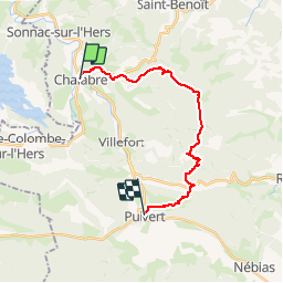
Tocht Stappen van 18,8 km beschikbaar op Occitanië, Aude, Chalabre. Deze tocht wordt voorgesteld door richard21220.

Beschrijving

Gîte et Chambres d'Hôtes La Peyrouse : La Peyrouse 11230 PUIVERT Tél 04 68 20 24 19

Chambres d'Hôtes La Métairie d'en Bor : 11230 PUIVERT Tél 06 73 39 87 80

Gîte d'Etape le Relais des Marionnettes : 19 route Départementale 117 11230 PUIVERT Tél 04 68 20 80 69

Chambres d'Hôtes Au Petit Verger : 8 route Départementale 117 11230 PUIVERT Tél 04 68 20 66 08

Chambres d'Hôtes Domaine Antonin : Camp Sylvestre 11230 PUIVERT Tél 04 68 20 80 27

Chambres d'Hôtes La Cocagnière : 3 place du Pijol Camp Sylvestre 11230 PUIVERT Tél 04 68 20 81 90

Hoogteprofiel

Plaatsbepaling

Land:
France
Regio :
Occitanië
Departement/Provincie :
Aude
Gemeente :
Chalabre
Locatie:
Unknown
Vertrek:(Dec)
Vertrek:(UTM)
419012 ; 4759338 (31T) N.

Wandeltochten in de omgeving

Tocht Stappen Rivel - Au fil de l'eau - Rivel - Photo
Stappen
tracegps

Stappen

Medium
(1)
Rivel, Occitanië, Aude, France
5,2 km | 7 km-effort
1h 45min
Ja
Tocht Stappen Rivel - Le chemin du château - Rivel - Photo
Stappen
tracegps

Stappen

Gemakkelijk
(1)
Rivel, Occitanië, Aude, France
2,4 km | 4 km-effort
45min
Ja
Tocht Stappen Montbel - Lac de Montbel - Photo
Stappen
tracegps

Stappen

Medium
(2)
Montbel, Occitanië, Ariège, France
15,8 km | 18,4 km-effort
3h 19min
Ja
Tocht Te voet Montbel - Tour du Lac de Montbel - Photo
Te voet
PRO

Te voet

Gemakkelijk
Montbel, Occitanië, Ariège, France
15,3 km | 17,9 km-effort
4h 4min
Ja
Tocht Fiets Chalabre - Chalabre - Limoux - Espéraza - Photo
Fiets
tracegps

Fiets

Moeilijk
Chalabre, Occitanië, Aude, France
72 km | 88 km-effort
4h 30min
Ja
Tocht Paard Chalabre - La colline du calvaire - Chalabre - Photo
Paard
tracegps

Paard

Gemakkelijk
Chalabre, Occitanië, Aude, France
4,4 km | 6,4 km-effort
1h 0min
Ja
Tocht Stappen Chalabre - La colline du calvaire - Chalabre - Photo
Stappen
tracegps

Stappen

Gemakkelijk
Chalabre, Occitanië, Aude, France
4,4 km | 6,4 km-effort
1h 30min
Ja
Tocht Stappen Chalabre - Circuit de découverte de Chalabre - Photo
Stappen
tracegps

Stappen

Gemakkelijk
Chalabre, Occitanië, Aude, France
3,5 km | 3,9 km-effort
1h 0min
Ja
Tocht Paard Chalabre - Histoires d'eau et de train - Chalabre - Photo
Paard
tracegps

Paard

Moeilijk
Chalabre, Occitanië, Aude, France
23 km | 28 km-effort
4h 0min
Ja


Sluiten
Mijn abonnementen