Tocht Stappen Saint-Christophe - grottes de Saint-Christophe  - Photo

grottes de Saint-Christophe

 phil88
phil88

Gebruiker

© OpenStreetMap contributors
Lengte
Lengte
7,7 km
Max. hoogte
Max. hoogte
599 m
Positief hoogteverschil
351 m
Km-Effort
Km-Effort  
12,3 km
Min. hoogte
Min. hoogte
416 m
Negatief hoogteverschil
350 m
Boucle
Boucle
Ja
Datum van aanmaak :
2017-04-16 00:00:00.0
Laatste wijziging :
2017-04-16 00:00:00.0

(0 Bericht)

Stappen
Stappen
5h14
Moeilijkheid : Medium

Scan deze QR-code om de tocht te openen in de SityTrail-applicatie

Gratisgps-wandelapplicatie

Logo SityTrail SityTrail

IGN / Geografische instituten

SityTrail uit de App Store downloaden SityTrail uit Google Play downloaden

Logo SityTrail SityTrail World

De wereld gaat voor u open

SityTrail uit de App Store downloaden SityTrail uit Google Play downloaden SityTrail op Huawei AppGallery downloaden

Over ons

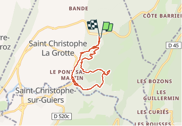
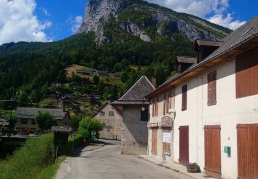
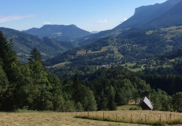
Tocht Stappen van 7,7 km beschikbaar op Auvergne-Rhône-Alpes, Savoie, Saint-Christophe. Deze tocht wordt voorgesteld door phil88.

Beschrijving

Chambery

Hoogteprofiel

Foto's

POI's

POI Saint-Christophe - Point 1 - Photo
phil88
SAINT-CHRISTOPHE 
POI Saint-Christophe - Point 2 - Photo
phil88
SAINT-CHRISTOPHE 
POI Saint-Christophe - Point 3 - Photo
phil88
SAINT-CHRISTOPHE 
POI Saint-Christophe - Point 5 - Photo
phil88
SAINT-CHRISTOPHE 

Plaatsbepaling

Land:
France
Regio :
Auvergne-Rhône-Alpes
Departement/Provincie :
Savoie
Gemeente :
Saint-Christophe
Locatie:
Unknown
Vertrek:(Dec)
Vertrek:(UTM)
718326 ; 5037022 (31T) N.

Wandeltochten in de omgeving

Tocht Sneeuwschoenen Saint-Christophe-sur-Guiers - Le Belvédère d'Arpison - Photo
Sneeuwschoenen
patjobou

Sneeuwschoenen

Medium
(1)
Saint-Christophe-sur-Guiers, Auvergne-Rhône-Alpes, Isère, France
11,1 km | 17,4 km-effort
4h 43min
Ja
Tocht Stappen Attignat-Oncin - Le Mont Grelle 1425m, depuis Attignat - Oncin - Photo
Stappen
tracegps

Stappen

Medium
(3)
Attignat-Oncin, Auvergne-Rhône-Alpes, Savoie, France
9,6 km | 17,6 km-effort
4h 30min
Ja
Tocht Stappen Saint-Pierre-d'Entremont - Roche Veyrand par les Clapiers, 1429m - Photo
Stappen
tracegps

Stappen

Moeilijk
(1)
Saint-Pierre-d'Entremont, Auvergne-Rhône-Alpes, Savoie, France
4,8 km | 14,3 km-effort
4h 10min
Ja
Tocht Stappen Saint-Christophe - la voie SARDE / tunnel des l'Echelles /st Christophe sur Guiers - Photo
Stappen
okfred26

Stappen

Zeer moeilijk
Saint-Christophe, Auvergne-Rhône-Alpes, Savoie, France
15,1 km | 23 km-effort
5h 12min
Ja
Tocht Stappen Saint-Christophe - 190323 Boucle voie Sarde - Photo
Stappen
mzonzon05

Stappen

Moeilijk
Saint-Christophe, Auvergne-Rhône-Alpes, Savoie, France
9,7 km | 15,6 km-effort
3h 50min
Ja
Tocht Stappen Saint-Christophe - Grottes des Echelles - Photo
Stappen
cousam

Stappen

Medium
Saint-Christophe, Auvergne-Rhône-Alpes, Savoie, France
7,4 km | 12,1 km-effort
3h 16min
Ja
Tocht Stappen La Bauche - Ballade vers la Bauche - Photo
Stappen
nadd73

Stappen

Gemakkelijk
La Bauche, Auvergne-Rhône-Alpes, Savoie, France
11,7 km | 23 km-effort
6h 19min
Ja
Tocht Stappen Saint-Pierre-d'Entremont - Saint Pierre d'Entremont (Isère) Cirque de Saint Même  - Photo
Stappen
zazie

Stappen

Medium
Saint-Pierre-d'Entremont, Auvergne-Rhône-Alpes, Isère, France
11,4 km | 18,7 km-effort
2h 44min
Ja
Tocht Stappen Saint-Pierre-d'Entremont - Étape 20 variante St Pierre d’Entremont - St Pierre de Chartreuse  - Photo
Stappen
pcugnod

Stappen

Medium
Saint-Pierre-d'Entremont, Auvergne-Rhône-Alpes, Isère, France
14,6 km | 0 m-effort
5h 5min
Neen


Sluiten
Mijn abonnementen