Tocht Stappen Sceaux - Sceaux Robinson MR - Photo
 jctinchebray
jctinchebray

Gebruiker

© OpenStreetMap contributors
Lengte
Lengte
16,8 km
Max. hoogte
Max. hoogte
176 m
Positief hoogteverschil
289 m
Km-Effort
Km-Effort  
21 km
Min. hoogte
Min. hoogte
57 m
Negatief hoogteverschil
287 m
Boucle
Boucle
Ja
Datum van aanmaak :
2017-04-26 00:00:00.0
Laatste wijziging :
2017-04-26 00:00:00.0

(0 Bericht)

Stappen
Stappen
4h27
Moeilijkheid : Medium

Scan deze QR-code om de tocht te openen in de SityTrail-applicatie

Gratisgps-wandelapplicatie

Logo SityTrail SityTrail

IGN / Geografische instituten

SityTrail uit de App Store downloaden SityTrail uit Google Play downloaden

Logo SityTrail SityTrail World

De wereld gaat voor u open

SityTrail uit de App Store downloaden SityTrail uit Google Play downloaden SityTrail op Huawei AppGallery downloaden

Over ons

Tocht Stappen van 16,8 km beschikbaar op Île-de-France, Hauts-de-Seine, Sceaux. Deze tocht wordt voorgesteld door jctinchebray.

Beschrijving

Randonnée boucle de 17 km au départ du parc de Sceaux et passant par Chatenay Malabry, Plessis Robinson, le parc de la vallée aux loups.

Hoogteprofiel

Plaatsbepaling

Land:
France
Regio :
Île-de-France
Departement/Provincie :
Hauts-de-Seine
Gemeente :
Sceaux
Locatie:
Unknown
Vertrek:(Dec)
Vertrek:(UTM)
448837 ; 5402709 (31U) N.

Wandeltochten in de omgeving

Tocht Stappen Verrières-le-Buisson - Sur les sentiers de découverte du Bois de Verrières - Photo
Stappen
tracegps

Stappen

Medium
(2)
Verrières-le-Buisson, Île-de-France, Essonne, France
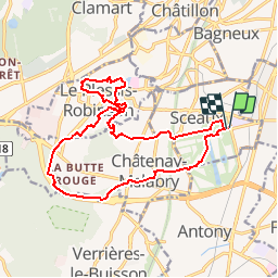
22 km | 27 km-effort
4h 40min
Ja
Tocht Stappen Sceaux - Les Hauts de Bièvre - Photo
Stappen
tracegps

Stappen

Moeilijk
(2)
Sceaux, Île-de-France, Hauts-de-Seine, France
25 km | 30 km-effort
6h 0min
Ja
Tocht Stappen Fontenay-aux-Roses -  Rando des 3 Parcs ! (des Gares RER) - Photo
Stappen
dmj41

Stappen

Zeer moeilijk
(2)
Fontenay-aux-Roses, Île-de-France, Hauts-de-Seine, France
15,9 km | 19,5 km-effort
4h 26min
Neen
Tocht Te voet Antony - Sur la Rive Gauche de la Bièvre - Photo
Te voet
PRO

Te voet

Gemakkelijk
Antony, Île-de-France, Hauts-de-Seine, France
5 km | 6,2 km-effort
1h 24min
Neen
Tocht Stappen Clamart - Tour des etangs - Bois de Clamart et de Meudon - Photo
Stappen
GUIDE
affinetataille

Stappen

Gemakkelijk
Clamart, Île-de-France, Hauts-de-Seine, France
8 km | 9,9 km-effort
2h 16min
Ja
Tocht Stappen Antony - De gare à gare - Photo
Stappen
micheldelaramdo

Stappen

Gemakkelijk
(1)
Antony, Île-de-France, Hauts-de-Seine, France
6,4 km | 7,2 km-effort
1h 29min
Neen
Tocht Stappen Gentilly - BAGNEUX _ GENTILLY 5 KM - Photo
Stappen
gemau77

Stappen

Medium
(1)
Gentilly, Île-de-France, Val-de-Marne, France
5,3 km | 6,2 km-effort
1h 23min
Neen
Tocht Stappen Sceaux - Sur les pas de Châteaubriant  - Photo
Stappen
c.chehere

Stappen

Medium
Sceaux, Île-de-France, Hauts-de-Seine, France
16,7 km | 20 km-effort
4h 33min
Ja
Tocht Stappen Bagneux - Chatillon - Photo
Stappen
c.chehere

Stappen

Gemakkelijk
Bagneux, Île-de-France, Hauts-de-Seine, France
13,7 km | 16 km-effort
3h 31min
Ja


Sluiten
Mijn abonnementen