Tocht Stappen Conamara Municipal District - Maumturks  - Photo
 heb
heb

Gebruiker

© OpenStreetMap contributors
Lengte
Lengte
11,7 km
Max. hoogte
Max. hoogte
690 m
Positief hoogteverschil
746 m
Km-Effort
Km-Effort  
22 km
Min. hoogte
Min. hoogte
55 m
Negatief hoogteverschil
747 m
Boucle
Boucle
Ja
Datum van aanmaak :
2017-06-30 00:00:00.0
Laatste wijziging :
2017-06-30 00:00:00.0

(1 Bericht)

Stappen
Stappen
4h22
Moeilijkheid : Moeilijk

Scan deze QR-code om de tocht te openen in de SityTrail-applicatie

Gratisgps-wandelapplicatie

Logo SityTrail SityTrail

IGN / Geografische instituten

SityTrail uit de App Store downloaden SityTrail uit Google Play downloaden

Logo SityTrail SityTrail World

De wereld gaat voor u open

SityTrail uit de App Store downloaden SityTrail uit Google Play downloaden SityTrail op Huawei AppGallery downloaden

Over ons

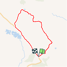
Tocht Stappen van 11,7 km beschikbaar op Onbekend, County Galway, Conamara Municipal District. Deze tocht wordt voorgesteld door heb.

Beschrijving

twelfe bens. Une randonnée en boucle au départ du parking de Maumeen   pics des Maumturk Mountain. Ce parcours n'est pas balisé.  

Hoogteprofiel

Plaatsbepaling

Land:
Ireland
Regio :
Onbekend
Departement/Provincie :
County Galway
Gemeente :
Conamara Municipal District
Locatie:
Illion ED
Vertrek:(Dec)
Vertrek:(UTM)
455544 ; 5926298 (29U) N.

Opmerkingen

Gelieve in te loggen om een commentaar of een beoordeling achter te laten


Wandeltochten in de omgeving

Tocht Stappen Conamara Municipal District - Irlande 4 - Photo
Stappen
jeanyvesjacquetton

Stappen

Gemakkelijk
Conamara Municipal District, Onbekend, County Galway, Ireland
17,3 km | 20 km-effort
5h 16min
Neen


Sluiten
Mijn abonnementen