Tocht Stappen Lachapelle-aux-Pots - Lachapelle aux pots - Photo
© OpenStreetMap contributors
Lengte
Lengte
10,2 km
Max. hoogte
Max. hoogte
152 m
Positief hoogteverschil
136 m
Km-Effort
Km-Effort  
12 km
Min. hoogte
Min. hoogte
84 m
Negatief hoogteverschil
136 m
Boucle
Boucle
Ja
Datum van aanmaak :
2018-04-17 13:01:49.64
Laatste wijziging :
2018-04-17 13:01:49.64

(0 Bericht)

Stappen
Stappen
2h37
Moeilijkheid : Gemakkelijk

Scan deze QR-code om de tocht te openen in de SityTrail-applicatie

Gratisgps-wandelapplicatie

Logo SityTrail SityTrail

IGN / Geografische instituten

SityTrail uit de App Store downloaden SityTrail uit Google Play downloaden

Logo SityTrail SityTrail World

De wereld gaat voor u open

SityTrail uit de App Store downloaden SityTrail uit Google Play downloaden SityTrail op Huawei AppGallery downloaden

Over ons

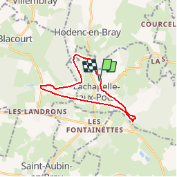
Tocht Stappen van 10,2 km beschikbaar op Hauts-de-France, Oise, Lachapelle-aux-Pots. Deze tocht wordt voorgesteld door Marie-Claire-mcp.

Beschrijving

Lachapelle aux pots, rue de la Gare - Voie verte jusqu'à Vivier Danger - route à gauche puis chemin à gauche au virage jusqu'à Lachapelle aux pots (rue de la ferme)puis rue de Gerberoy - continuer dans le bois jusqu'au Rutoire - Traverser la route et au bout du chemin à gauche puis direction Blacourt à droite et à la route à droite puis La Boissière et chemin noir à gauche - La Fontaine Modet à gauche - puis Voie verte à gauche jusqu'à Lachapelle aux pots

Hoogteprofiel

Plaatsbepaling

Land:
France
Regio :
Hauts-de-France
Departement/Provincie :
Oise
Gemeente :
Lachapelle-aux-Pots
Locatie:
Unknown
Vertrek:(Dec)
Vertrek:(UTM)
420529 ; 5478156 (31U) N.

Wandeltochten in de omgeving

Tocht Mountainbike Lachapelle-aux-Pots - ACTIVE LOG 003 - Photo
Mountainbike
sebcar

Mountainbike

Medium
(1)
Lachapelle-aux-Pots, Hauts-de-France, Oise, France
19,1 km | 24 km-effort
1h 39min
Ja
Tocht Mountainbike Pierrefitte-en-Beauvaisis - Grand tour - Photo
Mountainbike
jjeletufe

Mountainbike

(1)
Pierrefitte-en-Beauvaisis, Hauts-de-France, Oise, France
30 km | 35 km-effort
1h 44min
Ja
Tocht Stappen Senantes - Senantes - Photo
Stappen
jpblimond

Stappen

Medium
Senantes, Hauts-de-France, Oise, France
18,7 km | 23 km-effort
4h 47min
Ja
Tocht Stappen Lachapelle-aux-Pots - Lachapelle-aux-pots - Héricourt - La Frénoye - Armentières - Photo
Stappen
Marie-Claire-mcp

Stappen

Moeilijk
Lachapelle-aux-Pots, Hauts-de-France, Oise, France
10,7 km | 13,7 km-effort
3h 6min
Ja
Tocht Stappen Lachapelle-aux-Pots - Lachapelle aux pots - Armentières 11 km - Photo
Stappen
Marie-Claire-mcp

Stappen

Moeilijk
Lachapelle-aux-Pots, Hauts-de-France, Oise, France
10,6 km | 13,5 km-effort
3h 4min
Ja
Tocht Stappen Lachapelle-aux-Pots - Lachapelle aux Pots - Rando santé 1 - Photo
Stappen
marcel.F

Stappen

Medium
Lachapelle-aux-Pots, Hauts-de-France, Oise, France
5,6 km | 6,4 km-effort
1h 24min
Ja
Tocht Stappen Lachapelle-aux-Pots - Lachapelle-aux-Pots - autour de la Crapaudière vers 2 - Photo
Stappen
marcel.F

Stappen

Gemakkelijk
Lachapelle-aux-Pots, Hauts-de-France, Oise, France
9,9 km | 11,5 km-effort
2h 32min
Ja
Tocht Stappen Lachapelle-aux-Pots - Lachapelle-aux-Pots - autour de la Crapaudière - Photo
Stappen
marcel.F

Stappen

Gemakkelijk
Lachapelle-aux-Pots, Hauts-de-France, Oise, France
9,4 km | 10,9 km-effort
2h 25min
Ja
Tocht Stappen Lachapelle-aux-Pots - Lachapelle aux pots Gare - Photo
Stappen
Marie-Claire-mcp

Stappen

Medium
Lachapelle-aux-Pots, Hauts-de-France, Oise, France
10,6 km | 12,4 km-effort
2h 37min
Ja


Sluiten
Mijn abonnementen