Tocht Mountainbike Vidouze - Vidouze - Sombrun - Lascazères - Km 33 - Photo

Vidouze - Sombrun - Lascazères - Km 33

 potofe
potofe

Gebruiker

© OpenStreetMap contributors
Lengte
Lengte
33 km
Max. hoogte
Max. hoogte
295 m
Positief hoogteverschil
679 m
Km-Effort
Km-Effort  
42 km
Min. hoogte
Min. hoogte
164 m
Negatief hoogteverschil
675 m
Boucle
Boucle
Ja
Datum van aanmaak :
2018-09-07 19:22:06.404
Laatste wijziging :
2018-09-07 19:22:06.404

(0 Bericht)

Mountainbike
Mountainbike
2h43
Moeilijkheid : Medium

Scan deze QR-code om de tocht te openen in de SityTrail-applicatie

Gratisgps-wandelapplicatie

Logo SityTrail SityTrail

IGN / Geografische instituten

SityTrail uit de App Store downloaden SityTrail uit Google Play downloaden

Logo SityTrail SityTrail World

De wereld gaat voor u open

SityTrail uit de App Store downloaden SityTrail uit Google Play downloaden SityTrail op Huawei AppGallery downloaden

Over ons

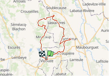
Tocht Mountainbike van 33 km beschikbaar op Occitanië, Hautes-Pyrénées, Vidouze. Deze tocht wordt voorgesteld door potofe.

Beschrijving

Circuit n°5 modifié : Au cœur du Madiranais
MONCAUP, MONPEZAT
Voici une boucle esthétique propice à l’évasion. Quiétude garantie dans les forêts aux essences variées. Quel plaisir de traverser ces campagnes au bâti traditionnel remarquable.

Hoogteprofiel

Plaatsbepaling

Land:
France
Regio :
Occitanië
Departement/Provincie :
Hautes-Pyrénées
Gemeente :
Vidouze
Locatie:
Unknown
Vertrek:(Dec)
Vertrek:(UTM)
738742 ; 4814354 (30T) N.

Wandeltochten in de omgeving

Tocht Stappen Bassillon-Vauzé - BASSILLON VAUZE G4
Stappen
GUIDE
marmotte65

Stappen

Moeilijk
Bassillon-Vauzé, Nieuw-Aquitanië, Pyrénées-Atlantiques, France
10,6 km | 12,8 km-effort
3h 18min
Ja
Tocht Stappen Bentayou-Sérée - LUCARE / ABERRE GR653A premier tronçon du secteur A 2801487 - Photo
Stappen
GUIDE
marmotte65

Stappen

Moeilijk
Bentayou-Sérée, Nieuw-Aquitanië, Pyrénées-Atlantiques, France
11,7 km | 15,2 km-effort
3h 8min
Neen
Tocht Stappen Moncaup - MONCAUP-Circuit vert des fontaines - Photo
Stappen
Polo-31

Stappen

Heel gemakkelijk
Moncaup, Nieuw-Aquitanië, Pyrénées-Atlantiques, France
9,9 km | 13 km-effort
2h 47min
Ja
Tocht Te voet Moncaup - 2020-08-15_19h39m22_Cirkwi-Le_sentier_des_fontaines (1) - Photo
Te voet
GUIDE
marmotte65

Te voet

Gemakkelijk
Moncaup, Nieuw-Aquitanië, Pyrénées-Atlantiques, France
13,4 km | 17,6 km-effort
Onbekend
Ja
Tocht Stappen Moncaup - MONCAUP  chemin des fontaines M1-fait - Photo
Stappen
GUIDE
marmotte65

Stappen

Gemakkelijk
Moncaup, Nieuw-Aquitanië, Pyrénées-Atlantiques, France
9,7 km | 12,3 km-effort
2h 41min
Ja
Tocht Te voet Luc-Armau - 2022-04-25 16-37-38 - Photo
Te voet
GUIDE
marmotte65

Te voet

Gemakkelijk
Luc-Armau, Nieuw-Aquitanië, Pyrénées-Atlantiques, France
12,6 km | 16,1 km-effort
3h 39min
Neen
Tocht Te voet Moncaup - VB N12 - Photo
Te voet
GUIDE
marmotte65

Te voet

Medium
Moncaup, Nieuw-Aquitanië, Pyrénées-Atlantiques, France
13,4 km | 17,6 km-effort
Onbekend
Ja
Tocht Te voet Luc-Armau - SityTrail - GR 653 - A   Nicolau-Pujo-Luccare- Mor... - Photo
Te voet
GUIDE
marmotte65

Te voet

Medium
Luc-Armau, Nieuw-Aquitanië, Pyrénées-Atlantiques, France
22 km | 27 km-effort
Onbekend
Neen
Tocht Fietstoerisme Lembeye - Lembeye - Châteaux et vignobles du Madiran - Circuit long - 64 Km - Photo
Fietstoerisme
potofe

Fietstoerisme

Zeer moeilijk
Lembeye, Nieuw-Aquitanië, Pyrénées-Atlantiques, France
64 km | 80 km-effort
3h 53min
Ja


Sluiten
Mijn abonnementen