Tocht Stappen Ledro - Malga Trat / Rifugio Pernici / Cima Pari  - Photo

Malga Trat / Rifugio Pernici / Cima Pari

 Dhendrickx71
Dhendrickx71

Gebruiker

© OpenStreetMap contributors
Lengte
Lengte
9,4 km
Max. hoogte
Max. hoogte
1962 m
Positief hoogteverschil
621 m
Km-Effort
Km-Effort  
17,7 km
Min. hoogte
Min. hoogte
1432 m
Negatief hoogteverschil
617 m
Boucle
Boucle
Ja
Datum van aanmaak :
2018-04-17 13:30:36.517
Laatste wijziging :
2021-02-22 08:59:31.369

(0 Bericht)

Stappen
Stappen
3h54
Moeilijkheid : Medium

Scan deze QR-code om de tocht te openen in de SityTrail-applicatie

Gratisgps-wandelapplicatie

Logo SityTrail SityTrail

IGN / Geografische instituten

SityTrail uit de App Store downloaden SityTrail uit Google Play downloaden

Logo SityTrail SityTrail World

De wereld gaat voor u open

SityTrail uit de App Store downloaden SityTrail uit Google Play downloaden SityTrail op Huawei AppGallery downloaden

Over ons

Tocht Stappen van 9,4 km beschikbaar op Trento-Zuid-Tirol, Provincia di Trento, Ledro. Deze tocht wordt voorgesteld door Dhendrickx71.

Beschrijving

Take the forest path from the car park under the Malga Trat to the Malga. Then follow the path nr. 403 to the Nino Pernici refuge. From there follow the path nr. 413 (Trail of Peace) to Bocca Saval. Go up until you see the Malga below. Turn left on the cow trail to Cima Pari.After a breathtaking view of the Ledro valley and its lake from the top of Cima Pari (approx. 2000m above sea level) take the same path back down to Bocca Saval. Take a little visit to the Malga. Otherwise once at the Bocca Saval go up the path in front of you to Dos di Trat. Once you reach the top, go back up and follow the path of the cows towards Malga Trat and the car park.

Hoogteprofiel

Plaatsbepaling

Land:
Italy
Regio :
Trento-Zuid-Tirol
Departement/Provincie :
Provincia di Trento
Gemeente :
Ledro
Locatie:
Unknown
Vertrek:(Dec)
Vertrek:(UTM)
636408 ; 5086947 (32T) N.

Wandeltochten in de omgeving

Tocht Te voet Ledro - Sentiero Austroungarico 1915-1918 - Photo
Te voet
PRO

Te voet

Gemakkelijk
Ledro, Trento-Zuid-Tirol, Provincia di Trento, Italy
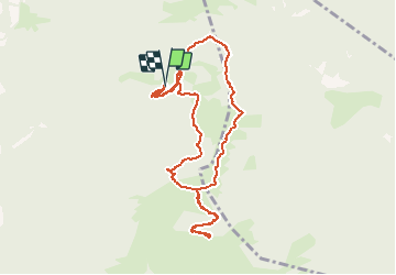
7,2 km | 15 km-effort
3h 23min
Neen
Tocht Te voet Ledro - Via ferrata del Bastione e della Rocchetta - Photo
Te voet
PRO

Te voet

Gemakkelijk
Ledro, Trento-Zuid-Tirol, Provincia di Trento, Italy
4,9 km | 8,5 km-effort
1h 56min
Neen
Tocht Te voet Ledro - Via de Ari e sentiero Rino Zanotti - Photo
Te voet
PRO

Te voet

Gemakkelijk
Ledro, Trento-Zuid-Tirol, Provincia di Trento, Italy
6,1 km | 11,6 km-effort
2h 38min
Neen
Tocht Te voet Ledro - Sentér de Giumela - Photo
Te voet
PRO

Te voet

Gemakkelijk
Ledro, Trento-Zuid-Tirol, Provincia di Trento, Italy
4,1 km | 7 km-effort
1h 35min
Neen
Tocht Te voet Tenno - Sentiero della Regina - Photo
Te voet
PRO

Te voet

Gemakkelijk
Tenno, Trento-Zuid-Tirol, Provincia di Trento, Italy
7 km | 19,9 km-effort
4h 30min
Neen
Tocht Te voet Ledro - Sentér de Saval - Photo
Te voet
PRO

Te voet

Gemakkelijk
Ledro, Trento-Zuid-Tirol, Provincia di Trento, Italy
5,7 km | 16,5 km-effort
3h 44min
Neen
Tocht Te voet Ledro - Sentér de Dromaé - Photo
Te voet
PRO

Te voet

Gemakkelijk
Ledro, Trento-Zuid-Tirol, Provincia di Trento, Italy
4,8 km | 8,2 km-effort
1h 51min
Neen
Tocht Te voet Fiavé - IT-O406 - Photo
Te voet
PRO

Te voet

Gemakkelijk
Fiavé, Trento-Zuid-Tirol, Provincia di Trento, Italy
7,2 km | 13 km-effort
2h 56min
Neen
Tocht Mountainbike Ledro - Lago di Ledro (Retour VTT à Arco) - Photo
Mountainbike
lopic125

Mountainbike

Heel gemakkelijk
(1)
Ledro, Trento-Zuid-Tirol, Provincia di Trento, Italy
21 km | 29 km-effort
1h 47min
Neen


Sluiten
Mijn abonnementen