Tocht Stappen Vineuil-Saint-Firmin - Chantilly Bourgognes - Photo
 Francine
Francine

Gebruiker

© OpenStreetMap contributors
Lengte
Lengte
13 km
Max. hoogte
Max. hoogte
80 m
Positief hoogteverschil
121 m
Km-Effort
Km-Effort  
14,6 km
Min. hoogte
Min. hoogte
37 m
Negatief hoogteverschil
121 m
Boucle
Boucle
Ja
Datum van aanmaak :
2018-04-17 15:28:28.999
Laatste wijziging :
2018-04-17 15:28:28.999

(0 Bericht)

Stappen
Stappen
3h12
Moeilijkheid : Onbekend

Scan deze QR-code om de tocht te openen in de SityTrail-applicatie

Gratisgps-wandelapplicatie

Logo SityTrail SityTrail

IGN / Geografische instituten

SityTrail uit de App Store downloaden SityTrail uit Google Play downloaden

Logo SityTrail SityTrail World

De wereld gaat voor u open

SityTrail uit de App Store downloaden SityTrail uit Google Play downloaden SityTrail op Huawei AppGallery downloaden

Over ons

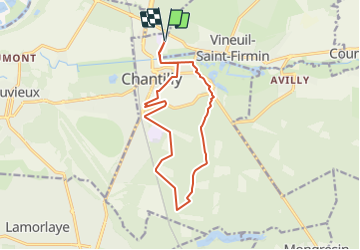
Tocht Stappen van 13 km beschikbaar op Hauts-de-France, Oise, Vineuil-Saint-Firmin. Deze tocht wordt voorgesteld door Francine.

Beschrijving

Chantilly bourgognes

Hoogteprofiel

Plaatsbepaling

Land:
France
Regio :
Hauts-de-France
Departement/Provincie :
Oise
Gemeente :
Vineuil-Saint-Firmin
Locatie:
Unknown
Vertrek:(Dec)
Vertrek:(UTM)
461271 ; 5450018 (31U) N.

Wandeltochten in de omgeving

Tocht Stappen Apremont - apremont 60300 - Photo
Stappen
dartoisclaude

Stappen

Moeilijk
(1)
Apremont, Hauts-de-France, Oise, France
20 km | 23 km-effort
4h 49min
Ja
Tocht Stappen Chantilly - chantilly Gouvieux - Photo
Stappen
Jacques Salfati

Stappen

Gemakkelijk
Chantilly, Hauts-de-France, Oise, France
20 km | 0 m-effort
5h 59min
Ja
Tocht Stappen Avilly-Saint-Léonard - randonnée en forêt de chantilly - Photo
Stappen
jumetz philippe

Stappen

Heel gemakkelijk
Avilly-Saint-Léonard, Hauts-de-France, Oise, France
12,1 km | 13,2 km-effort
2h 54min
Ja
Tocht Stappen Saint-Leu-d'Esserent - CRAB : Saint Leu d'Esserent - Photo
Stappen
PatRando

Stappen

Gemakkelijk
Saint-Leu-d'Esserent, Hauts-de-France, Oise, France
24 km | 28 km-effort
6h 7min
Ja
Tocht Mountainbike Lamorlaye - Rando Velo 14 sep 14 - Photo
Mountainbike
domifon

Mountainbike

Gemakkelijk
(1)
Lamorlaye, Hauts-de-France, Oise, France
28 km | 32 km-effort
2h 6min
Ja
Tocht Mountainbike Chantilly - Dans la forêt de Chantilly - Photo
Mountainbike
tracegps

Mountainbike

Medium
Chantilly, Hauts-de-France, Oise, France
19,7 km | 22 km-effort
1h 30min
Ja
Tocht Stappen Chantilly - Dans la forêt de Chantilly - Photo
Stappen
tracegps

Stappen

Medium
Chantilly, Hauts-de-France, Oise, France
19,7 km | 22 km-effort
5h 0min
Ja
Tocht Stappen Chantilly - JG Chantilly Toudouze  ecuries Ctx - Photo
Stappen
jol60

Stappen

Gemakkelijk
Chantilly, Hauts-de-France, Oise, France
4,6 km | 5,1 km-effort
1h 10min
Ja
Tocht Stappen Orry-la-Ville - MR_ETANG-COMELLES_5.2Km - Photo
Stappen
GR77LP

Stappen

Gemakkelijk
(1)
Orry-la-Ville, Hauts-de-France, Oise, France
5,2 km | 5,9 km-effort
1h 18min
Ja


Sluiten
Mijn abonnementen