Tocht Stappen Manosque - Toutes-Aures en partant de Drouille - Photo
 liocol
liocol

Gebruiker

© OpenStreetMap contributors
Lengte
Lengte
6,3 km
Max. hoogte
Max. hoogte
468 m
Positief hoogteverschil
136 m
Km-Effort
Km-Effort  
8,1 km
Min. hoogte
Min. hoogte
345 m
Negatief hoogteverschil
136 m
Boucle
Boucle
Ja
Datum van aanmaak :
2018-04-17 16:25:49.718
Laatste wijziging :
2018-04-17 16:25:49.718

(0 Bericht)

Stappen
Stappen
1h48
Moeilijkheid : Gemakkelijk

Scan deze QR-code om de tocht te openen in de SityTrail-applicatie

Gratisgps-wandelapplicatie

Logo SityTrail SityTrail

IGN / Geografische instituten

SityTrail uit de App Store downloaden SityTrail uit Google Play downloaden

Logo SityTrail SityTrail World

De wereld gaat voor u open

SityTrail uit de App Store downloaden SityTrail uit Google Play downloaden SityTrail op Huawei AppGallery downloaden

Over ons

Tocht Stappen van 6,3 km beschikbaar op Provence-Alpes-Côte d'Azur, Alpes-de-Haute-Provence, Manosque. Deze tocht wordt voorgesteld door liocol.

Beschrijving

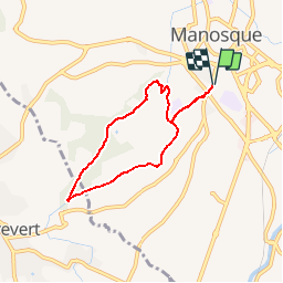
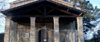
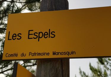
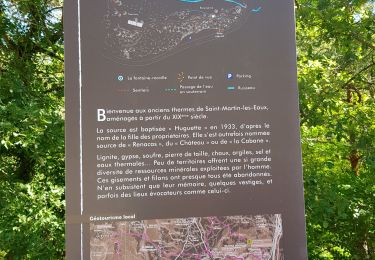
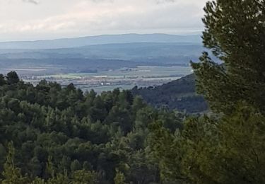
Garez vous sur le parking de Drouille, pas sur la rue, Zone bleue. Une boucle qui suit le canal, le GR et la Chapelle Toutes-Aures.

Hoogteprofiel

Foto's

POI's

POI Manosque - Point 1 - Photo
liocol
MANOSQUE 
POI Manosque - Point 2 - Photo
liocol
MANOSQUE 
POI Manosque - Point 3 - Photo
liocol
MANOSQUE 
POI Pierrevert - Point 4 - Photo
liocol
PIERREVERT 
POI Manosque - Point 5 - Photo
liocol
MANOSQUE 
POI Manosque - Point 6 - Photo
liocol
MANOSQUE 
POI Manosque - Point 7 - Photo
liocol
MANOSQUE 
POI Manosque - Point 8 - Photo
liocol
MANOSQUE 
POI Manosque - Point 10 - Photo
liocol
MANOSQUE 
POI Manosque - Point 11 - Photo
liocol
MANOSQUE 
POI Manosque - Point 12 - Photo
liocol
MANOSQUE 

Plaatsbepaling

Land:
France
Regio :
Provence-Alpes-Côte d'Azur
Departement/Provincie :
Alpes-de-Haute-Provence
Gemeente :
Manosque
Locatie:
Unknown
Vertrek:(Dec)
Vertrek:(UTM)
723726 ; 4856544 (31T) N.

Wandeltochten in de omgeving

Tocht Stappen Manosque - Le Val des Chats, avant le col de la Mort d'Imbert. - Photo
Stappen
liocol

Stappen

Gemakkelijk
(2)
Manosque, Provence-Alpes-Côte d'Azur, Alpes-de-Haute-Provence, France
4,7 km | 6,5 km-effort
1h 23min
Ja
Tocht Mountainbike Volx - Volx/Montaigu/Bellevue/La Garde - Photo
Mountainbike
remizzi

Mountainbike

Medium
(1)
Volx, Provence-Alpes-Côte d'Azur, Alpes-de-Haute-Provence, France
16,2 km | 24 km-effort
1h 33min
Ja
Tocht Stappen Manosque - Le tour de la borie '' pain de sucre ''  - Photo
Stappen
PITOUSSAINT

Stappen

Gemakkelijk
(1)
Manosque, Provence-Alpes-Côte d'Azur, Alpes-de-Haute-Provence, France
5,1 km | 7,4 km-effort
1h 43min
Ja
Tocht Stappen Manosque - Quartier des Espels, départ Piscine. - Photo
Stappen
liocol

Stappen

Gemakkelijk
(1)
Manosque, Provence-Alpes-Côte d'Azur, Alpes-de-Haute-Provence, France
4,8 km | 7,3 km-effort
1h 50min
Ja
Tocht Stappen Manosque - MANOSQUE VOLX PAR LES COLLINES O S - Photo
Stappen
RobinMicheline

Stappen

Moeilijk
Manosque, Provence-Alpes-Côte d'Azur, Alpes-de-Haute-Provence, France
17,7 km | 24 km-effort
4h 15min
Ja
Tocht Trail Volx - volx - Photo
Trail
francislassauce

Trail

Moeilijk
Volx, Provence-Alpes-Côte d'Azur, Alpes-de-Haute-Provence, France
9,2 km | 14,7 km-effort
1h 43min
Ja
Tocht Stappen Manosque - 1Les speels, le relais, le pain de sucre. Depart Crématoriome. - Photo
Stappen
liocol

Stappen

Medium
(1)
Manosque, Provence-Alpes-Côte d'Azur, Alpes-de-Haute-Provence, France
6,1 km | 9,7 km-effort
2h 4min
Ja
Tocht Stappen Saint-Martin-les-Eaux - 1Domaine de Bourne - Photo
Stappen
liocol

Stappen

Medium
Saint-Martin-les-Eaux, Provence-Alpes-Côte d'Azur, Alpes-de-Haute-Provence, France
5,6 km | 8,3 km-effort
2h 2min
Ja
Tocht Stappen Manosque - 1Gaude, boucle de Montaigu.  - Photo
Stappen
liocol

Stappen

Medium
Manosque, Provence-Alpes-Côte d'Azur, Alpes-de-Haute-Provence, France
6,6 km | 10,2 km-effort
2h 7min
Ja


Sluiten
Mijn abonnementen