![](/images/other/stat-length.png)
![Tocht Stappen Gréoux-les-Bains - ND des Oeufs par les Tronnes - Photo](https://media.geolcdn.com/t/1900/400/ext.pjpeg?maxdim=2&url=https%3A%2F%2Fservices.sitytrail.com%2FGeolivesWS%2FDownloadMedia.ashx%3FTrailID%3D935575%26Media%3Dfix__20180402170820.jpg)
ND des Oeufs par les Tronnes
aubr
Gebruiker
![Lengte](/images/other/stat-length.png)
Lengte
9 km
![Max. hoogte](https://static1.geolcdn.com/siteimages/upload/files/1508320355ic_sort_altitude_max_24dp.png)
Max. hoogte
451 m
![Positief hoogteverschil](https://static1.geolcdn.com/siteimages/upload/files/1508320355ic_sort_den_pos_24dp.png)
Positief hoogteverschil
256 m
![Km-Effort](/images/other/stat-length.png)
Km-Effort
12,4 km
![Min. hoogte](https://static1.geolcdn.com/siteimages/upload/files/1508320355ic_sort_altitude_min_24dp.png)
Min. hoogte
301 m
![Negatief hoogteverschil](https://static1.geolcdn.com/siteimages/upload/files/1508320355ic_sort_den_neg_24dp.png)
Negatief hoogteverschil
260 m
![Boucle](https://static1.geolcdn.com/siteimages/upload/files/16400158638029165_repeat_loop_refresh_sync_direction_icon.png)
Boucle
Ja
Datum van aanmaak :
2018-04-17 23:33:21.304
Laatste wijziging :
2018-04-17 23:33:21.304
![Stappen](https://static1.geolcdn.com/sitytour/trail-icons/101.png)
2h41
Moeilijkheid : Medium
![Scan deze QR-code om de tocht te openen in de SityTrail-applicatie](https://capi.geolives.com/qq0zvz2zws4bq2lad0pu/sitytour/trails/935575/qr.png?size=200)
Gratisgps-wandelapplicatie
Over ons
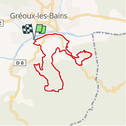
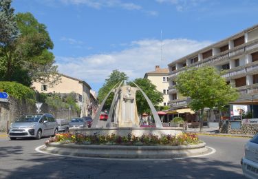
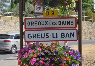
Tocht Stappen van 9 km beschikbaar op Provence-Alpes-Côte d'Azur, Alpes-de-Haute-Provence, Gréoux-les-Bains. Deze tocht wordt voorgesteld door aubr.
Beschrijving
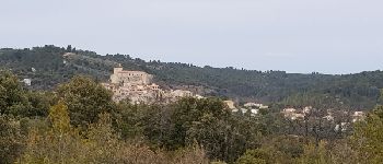
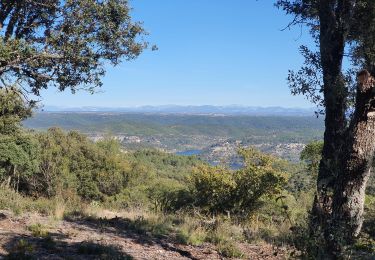
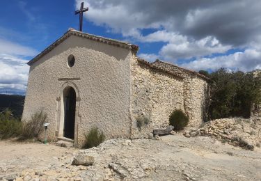
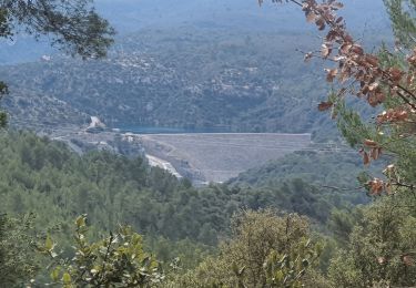
Notre Dame des Oeufs par les Tronnes
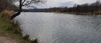
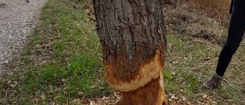
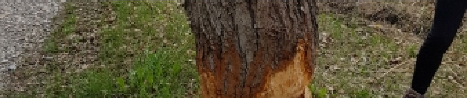
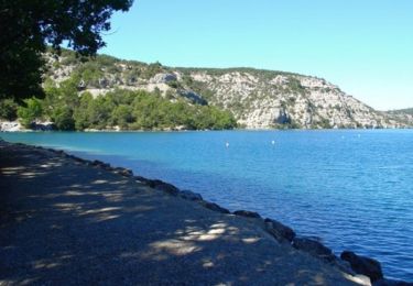
Boucle facile de 9Km au départ du parking du barrage du Verdon proche du camping de Verseau
Seule difficulté à la montée à ND des Oeufs
Plaatsbepaling
Land:
France
Regio :
Provence-Alpes-Côte d'Azur
Departement/Provincie :
Alpes-de-Haute-Provence
Gemeente :
Gréoux-les-Bains
Locatie:
Unknown
Vertrek:(Dec)
Vertrek:(UTM)
732081 ; 4848351 (31T) N.
Opmerkingen
Wandeltochten in de omgeving
![Tocht Stappen Gréoux-les-Bains - 20220612 - Gréoux les Bains - Découverte - Photo](https://media.geolcdn.com/t/375/260/ext.jpg?maxdim=2&url=https%3A%2F%2Fmedia.geolcdn.com%2Ff%2F06e7185f-acb6-4905-91b9-cbb5cb1584fb.JPG)
![Stappen Stappen](https://static1.geolcdn.com/sitytour/trail-icons/101.png)
20220612 - Gréoux les Bains - Découverte
Stappen
Medium
(1)
Gréoux-les-Bains,
Provence-Alpes-Côte d'Azur,
Alpes-de-Haute-Provence,
France
![](/images/other/stat-length.png)
6,2 km | 7,8 km-effort
2h 5min
![](https://static1.geolcdn.com/siteimages/upload/files/16400158638029165_repeat_loop_refresh_sync_direction_icon.png)
Ja
![Tocht Mountainbike Gréoux-les-Bains - De Gréoux les Bains au Lac d'Esparron - Photo](https://media.geolcdn.com/t/375/260/ext.jpg?maxdim=2&url=https%3A%2F%2Fservices.sitytrail.com%2FGeolivesWS%2FDownloadMedia.ashx%3FTrailID%3D129876%26Media%3D13444_1.jpg)
![Mountainbike Mountainbike](https://static1.geolcdn.com/sitytour/trail-icons/202.png)
De Gréoux les Bains au Lac d'Esparron
Mountainbike
Medium
(2)
Gréoux-les-Bains,
Provence-Alpes-Côte d'Azur,
Alpes-de-Haute-Provence,
France
![](/images/other/stat-length.png)
22 km | 30 km-effort
2h 0min
![](https://static1.geolcdn.com/siteimages/upload/files/16400158638029165_repeat_loop_refresh_sync_direction_icon.png)
Ja
![Tocht Stappen Saint-Julien - 2022-11-11 Balcon de Saint Julien au lac d'Esparon - Photo](https://media.geolcdn.com/t/375/260/ext.jpg?maxdim=2&url=https%3A%2F%2Fmedia.geolcdn.com%2Ff%2F62e038c3-e228-4ae0-bf51-fb91477c57ba.jpg)
![Stappen Stappen](https://static1.geolcdn.com/sitytour/trail-icons/101.png)
2022-11-11 Balcon de Saint Julien au lac d'Esparon
Stappen
Medium
Saint-Julien,
Provence-Alpes-Côte d'Azur,
Var,
France
![](/images/other/stat-length.png)
16,9 km | 23 km-effort
4h 5min
![](https://static1.geolcdn.com/siteimages/upload/files/16400158638029165_repeat_loop_refresh_sync_direction_icon.png)
Ja
![Tocht Stappen Gréoux-les-Bains - 20220617 - Gréoux 6.5 Km - Photo](https://media.geolcdn.com/t/375/260/ext.jpg?maxdim=2&url=https%3A%2F%2Fmedia.geolcdn.com%2Ff%2F321efddc-dddd-4879-ac94-5fa683e650b0.JPG)
![Stappen Stappen](https://static1.geolcdn.com/sitytour/trail-icons/101.png)
20220617 - Gréoux 6.5 Km
Stappen
Medium
Gréoux-les-Bains,
Provence-Alpes-Côte d'Azur,
Alpes-de-Haute-Provence,
France
![](/images/other/stat-length.png)
6,5 km | 7,9 km-effort
2h 0min
![](https://static1.geolcdn.com/siteimages/upload/files/16400158638029165_repeat_loop_refresh_sync_direction_icon.png)
Ja
![Tocht Stappen Gréoux-les-Bains - 20220616 - Gréoux-les-Bains - Visite château - Photo](https://media.geolcdn.com/t/375/260/ext.jpg?maxdim=2&url=https%3A%2F%2Fmedia.geolcdn.com%2Ff%2F7a51e815-7ca6-46e5-aa34-638d99f629ae.JPG)
![Stappen Stappen](https://static1.geolcdn.com/sitytour/trail-icons/101.png)
20220616 - Gréoux-les-Bains - Visite château
Stappen
Medium
Gréoux-les-Bains,
Provence-Alpes-Côte d'Azur,
Alpes-de-Haute-Provence,
France
![](/images/other/stat-length.png)
6,9 km | 9 km-effort
2h 34min
![](https://static1.geolcdn.com/siteimages/upload/files/16400158638029165_repeat_loop_refresh_sync_direction_icon.png)
Ja
![Tocht Stappen Gréoux-les-Bains - 08-04-2022 Gréoux - Les Maurras - Photo](https://media.geolcdn.com/t/375/260/ext.jpg?maxdim=2&url=https%3A%2F%2Fmedia.geolcdn.com%2Ff%2F3f4d635a-05b2-45c2-b069-140ff93f8fb8.jpg)
![Stappen Stappen](https://static1.geolcdn.com/sitytour/trail-icons/101.png)
08-04-2022 Gréoux - Les Maurras
Stappen
Gemakkelijk
Gréoux-les-Bains,
Provence-Alpes-Côte d'Azur,
Alpes-de-Haute-Provence,
France
![](/images/other/stat-length.png)
15,2 km | 21 km-effort
3h 43min
![](https://static1.geolcdn.com/siteimages/upload/files/16400158638029165_repeat_loop_refresh_sync_direction_icon.png)
Ja
![Tocht Stappen Gréoux-les-Bains - 06-04-2022 Gréoux - St Martin de Brômes - Photo](https://media.geolcdn.com/t/375/260/ext.jpg?maxdim=2&url=https%3A%2F%2Fmedia.geolcdn.com%2Ff%2Ff105afad-45ad-4f2e-b245-baf7142bb320.jpg)
![Stappen Stappen](https://static1.geolcdn.com/sitytour/trail-icons/101.png)
06-04-2022 Gréoux - St Martin de Brômes
Stappen
Moeilijk
Gréoux-les-Bains,
Provence-Alpes-Côte d'Azur,
Alpes-de-Haute-Provence,
France
![](/images/other/stat-length.png)
13,8 km | 19,2 km-effort
3h 44min
![](https://static1.geolcdn.com/siteimages/upload/files/16400158638029165_repeat_loop_refresh_sync_direction_icon.png)
Ja
![Tocht Mountainbike Gréoux-les-Bains - VTT Single spirit - Gréoux les Bains - Photo](https://media.geolcdn.com/t/375/260/ext.jpg?maxdim=2&url=https%3A%2F%2Fstatic1.geolcdn.com%2Fsiteimages%2Fupload%2Ffiles%2F1524743154velo.jpg)
![Mountainbike Mountainbike](https://static1.geolcdn.com/sitytour/trail-icons/202.png)
VTT Single spirit - Gréoux les Bains
Mountainbike
Moeilijk
(2)
Gréoux-les-Bains,
Provence-Alpes-Côte d'Azur,
Alpes-de-Haute-Provence,
France
![](/images/other/stat-length.png)
18,2 km | 25 km-effort
1h 30min
![](https://static1.geolcdn.com/siteimages/upload/files/16400158638029165_repeat_loop_refresh_sync_direction_icon.png)
Ja
![Tocht Stappen Gréoux-les-Bains - Marchand de nuages court - Photo](https://media.geolcdn.com/t/375/260/ext.jpg?maxdim=2&url=https%3A%2F%2Fmedia.geolcdn.com%2Ff%2Fe4aa1ae3-ac2d-425d-8a16-af6f31e3dcd8.jpg)
![Stappen Stappen](https://static1.geolcdn.com/sitytour/trail-icons/101.png)
Marchand de nuages court
Stappen
Medium
Gréoux-les-Bains,
Provence-Alpes-Côte d'Azur,
Alpes-de-Haute-Provence,
France
![](/images/other/stat-length.png)
6,8 km | 9,3 km-effort
2h 3min
![](https://static1.geolcdn.com/siteimages/upload/files/16400158638029165_repeat_loop_refresh_sync_direction_icon.png)
Ja