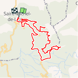
11 km | 15,3 km-effort
les dolmens de saint michel de llottes
stef789
Gebruiker
Lengte
12,3 km
Max. hoogte
516 m
Positief hoogteverschil
445 m
Km-Effort
18,3 km
Min. hoogte
186 m
Negatief hoogteverschil
446 m
Boucle
Ja
Datum van aanmaak :
2018-04-18 00:04:48.139
Laatste wijziging :
2018-04-18 00:04:48.139
4h29
Moeilijkheid : Gemakkelijk
Gratisgps-wandelapplicatie
Over ons
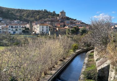
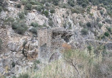
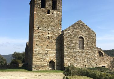
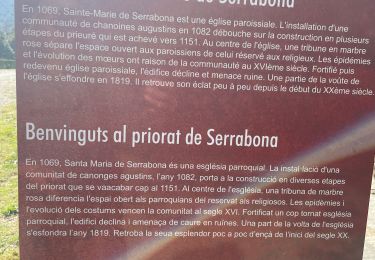
Tocht Stappen van 12,3 km beschikbaar op Occitanië, Pyrénées-Orientales, Saint-Michel-de-Llotes. Deze tocht wordt voorgesteld door stef789.
Plaatsbepaling
Land:
France
Regio :
Occitanië
Departement/Provincie :
Pyrénées-Orientales
Gemeente :
Saint-Michel-de-Llotes
Locatie:
Unknown
Vertrek:(Dec)
Vertrek:(UTM)
469276 ; 4721670 (31T) N.
Opmerkingen
Wandeltochten in de omgeving
ILLE TÊT 66 - PIC PEDROUS - CASESNOVES
Stappen
Medium
(10)
Ille-sur-Têt,
Occitanië,
Pyrénées-Orientales,
France
2h 22min
Ja
route saint Michel
Stappen
Heel gemakkelijk
(1)
Caixas,
Occitanië,
Pyrénées-Orientales,
France
17 km | 24 km-effort
5h 40min
Ja
20240104 Tour depuis le prieuré de Serrabonne
Stappen
Medium
Boule-d'Amont,
Occitanië,
Pyrénées-Orientales,
France
15,2 km | 26 km-effort
4h 37min
Ja
Camelas Castelnou
Stappen
Gemakkelijk
Camélas,
Occitanië,
Pyrénées-Orientales,
France
11,7 km | 18 km-effort
4h 4min
Ja
Ille st jules
Stappen
Moeilijk
Ille-sur-Têt,
Occitanië,
Pyrénées-Orientales,
France
11,2 km | 12,7 km-effort
3h 2min
Ja
Bouleternere
Stappen
Medium
Bouleternère,
Occitanië,
Pyrénées-Orientales,
France
13,9 km | 20 km-effort
3h 52min
Ja
De Ille à rodés
Stappen
Zeer moeilijk
Ille-sur-Têt,
Occitanië,
Pyrénées-Orientales,
France
16,3 km | 22 km-effort
4h 34min
Ja
Serrabone /le roc rouge(le rocher du dragon):itinéraire 2
Stappen
Medium
Boule-d'Amont,
Occitanië,
Pyrénées-Orientales,
France
10,1 km | 17,5 km-effort
3h 32min
Ja
Serra une
Stappen
Medium
Boule-d'Amont,
Occitanië,
Pyrénées-Orientales,
France
10,4 km | 17,8 km-effort
3h 44min
Ja