Tocht Stappen Saint-Lumine-de-Coutais - Lac Grand Lieu - Photo
 LeonEvain
LeonEvain

Gebruiker

© OpenStreetMap contributors
Lengte
Lengte
14,8 km
Max. hoogte
Max. hoogte
24 m
Positief hoogteverschil
86 m
Km-Effort
Km-Effort  
16 km
Min. hoogte
Min. hoogte
-7 m
Negatief hoogteverschil
85 m
Boucle
Boucle
Ja
Datum van aanmaak :
2018-08-18 11:15:55.082
Laatste wijziging :
2018-08-18 11:15:55.082

(0 Bericht)

Stappen
Stappen
3h33
Moeilijkheid : Gemakkelijk

Scan deze QR-code om de tocht te openen in de SityTrail-applicatie

Gratisgps-wandelapplicatie

Logo SityTrail SityTrail

IGN / Geografische instituten

SityTrail uit de App Store downloaden SityTrail uit Google Play downloaden

Logo SityTrail SityTrail World

De wereld gaat voor u open

SityTrail uit de App Store downloaden SityTrail uit Google Play downloaden SityTrail op Huawei AppGallery downloaden

Over ons

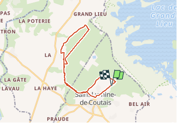
Tocht Stappen van 14,8 km beschikbaar op Pays de la Loire, Loire-Atlantique, Saint-Lumine-de-Coutais. Deze tocht wordt voorgesteld door LeonEvain.

Beschrijving

De St Lumine de Coutais à St Mars de Coutais  et retour
Exclusivement l'été
Marais inondable

Hoogteprofiel

Plaatsbepaling

Land:
France
Regio :
Pays de la Loire
Departement/Provincie :
Loire-Atlantique
Gemeente :
Saint-Lumine-de-Coutais
Locatie:
Unknown
Vertrek:(Dec)
Vertrek:(UTM)
597561 ; 5212832 (30T) N.

Wandeltochten in de omgeving

Tocht Te voet Saint-Lumine-de-Coutais - La Robrie - Photo
Te voet
PRO

Te voet

Gemakkelijk
Saint-Lumine-de-Coutais, Pays de la Loire, Loire-Atlantique, France
9,4 km | 10,2 km-effort
2h 19min
Ja
Tocht Te voet Machecoul-Saint-Même - 149 - Photo
Te voet
PRO

Te voet

Gemakkelijk
Machecoul-Saint-Même, Pays de la Loire, Loire-Atlantique, France
9,8 km | 10,7 km-effort
2h 26min
Ja
Tocht Stappen Saint-Mars-de-Coutais - Circuit du Tenu - Photo
Stappen
neoroll44

Stappen

Medium
Saint-Mars-de-Coutais, Pays de la Loire, Loire-Atlantique, France
10,9 km | 11,8 km-effort
3h 10min
Ja
Tocht Stappen Saint-Mars-de-Coutais - Circuit du Bois Charrette - Photo
Stappen
neoroll44

Stappen

Medium
Saint-Mars-de-Coutais, Pays de la Loire, Loire-Atlantique, France
10,1 km | 11 km-effort
2h 30min
Ja
Tocht Te voet Saint-Philbert-de-Grand-Lieu - L'Éclogite - Photo
Te voet
PRO

Te voet

Gemakkelijk
Saint-Philbert-de-Grand-Lieu, Pays de la Loire, Loire-Atlantique, France
4,3 km | 4,8 km-effort
1h 4min
Ja
Tocht Te voet Saint-Philbert-de-Grand-Lieu - Les Hauts du Lac - Photo
Te voet
PRO

Te voet

Gemakkelijk
Saint-Philbert-de-Grand-Lieu, Pays de la Loire, Loire-Atlantique, France
7,7 km | 8,3 km-effort
1h 53min
Ja
Tocht Te voet Machecoul-Saint-Même - Forêt de Machecoul - Photo
Te voet
PRO

Te voet

Gemakkelijk
Machecoul-Saint-Même, Pays de la Loire, Loire-Atlantique, France
6,8 km | 7,4 km-effort
1h 41min
Ja
Tocht Te voet Saint-Mars-de-Coutais - Le Moulin de la Nation - Photo
Te voet
PRO

Te voet

Gemakkelijk
Saint-Mars-de-Coutais, Pays de la Loire, Loire-Atlantique, France
6,5 km | 7,1 km-effort
1h 36min
Ja
Tocht Stappen Saint-Philbert-de-Grand-Lieu - Saint-Philbert-de-Grand-Lieu - Les Hauts du Lac - Photo
Stappen
TEFFRA

Stappen

Gemakkelijk
Saint-Philbert-de-Grand-Lieu, Pays de la Loire, Loire-Atlantique, France
9,5 km | 10,5 km-effort
2h 19min
Ja


Sluiten
Mijn abonnementen