![](/images/other/stat-length.png)
![Tour Wandern Blegny - Mortier - Photo](https://media.geolcdn.com/t/1900/400/ext.pjpeg?maxdim=2&url=https%3A%2F%2Fmedia.geolcdn.com%2Ff%2F8ae971b0-94ee-4292-831a-4bed9649b36e.jpg)
Mortier
mumu.larandonneuse
Benutzer GUIDE
![Länge](/images/other/stat-length.png)
Länge
15,6 km
![Maximale Höhe](https://static1.geolcdn.com/siteimages/upload/files/1508320355ic_sort_altitude_max_24dp.png)
Maximale Höhe
281 m
![Positive Höhendifferenz](https://static1.geolcdn.com/siteimages/upload/files/1508320355ic_sort_den_pos_24dp.png)
Positive Höhendifferenz
369 m
![Km-Effort](/images/other/stat-length.png)
Km-Effort
21 km
![Min. Höhe](https://static1.geolcdn.com/siteimages/upload/files/1508320355ic_sort_altitude_min_24dp.png)
Min. Höhe
172 m
![Negative Höhendifferenz](https://static1.geolcdn.com/siteimages/upload/files/1508320355ic_sort_den_neg_24dp.png)
Negative Höhendifferenz
369 m
![Boucle](https://static1.geolcdn.com/siteimages/upload/files/16400158638029165_repeat_loop_refresh_sync_direction_icon.png)
Boucle
Ja
Erstellungsdatum :
2020-11-23 08:36:04.068
Letzte Änderung :
2020-11-23 12:59:23.197
![Wandern](https://static1.geolcdn.com/sitytour/trail-icons/101.png)
3h35
Schwierigkeit : Medium
![Scannen Sie diesen QR-Code, um die Tour in der SityTrail-Anwendung zu öffnen](https://capi.geolives.com/qq0zvz2zws4bq2lad0pu/sitytour/trails/2605647/qr.png?size=200)
Kostenlosegpshiking-Anwendung
Über SityTrail
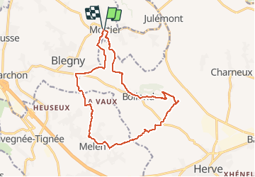
Tour Wandern von 15,6 km verfügbar auf Wallonien, Lüttich, Blegny. Diese Tour wird von mumu.larandonneuse vorgeschlagen.
Beschreibung
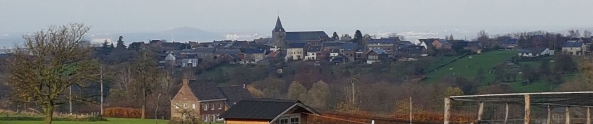
Superbe parcours campagnard au Pays de Herve avec une multitude de panoramas.
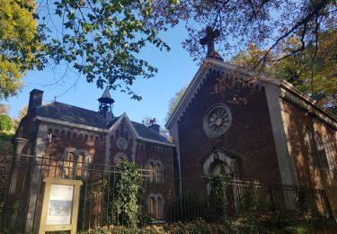
📍 Église de Mortier.
➡️📄 www.wandelgidszuidlimburg.com/routes-es-francais n° 322.
Ort
Land:
Belgium
Region :
Wallonien
Abteilung/Provinz :
Lüttich
Kommune :
Blegny
Standort:
Mortier
Gehen Sie:(Dec)
Gehen Sie:(UTM)
693786 ; 5618055 (31U) N.
Kommentare
Touren in der Umgebung
![Tour Wandern Dalhem - dalhem Bombaye aubin mortroux dalhem - Photo](https://media.geolcdn.com/t/375/260/ext.jpg?maxdim=2&url=https%3A%2F%2Fmedia.geolcdn.com%2Ff%2F16a64587-f39e-4282-a4fc-c52e1169e4ec.jpg)
![Wandern Wandern](https://static1.geolcdn.com/sitytour/trail-icons/101.png)
dalhem Bombaye aubin mortroux dalhem
Wandern
Einfach
(5)
Dalhem,
Wallonien,
Lüttich,
Belgium
![](/images/other/stat-length.png)
10,9 km | 12,6 km-effort
2h 40min
![](https://static1.geolcdn.com/siteimages/upload/files/16400158638029165_repeat_loop_refresh_sync_direction_icon.png)
Ja
![Tour Wandern Dalhem - dalhem tunnel . nelhain . la tombe . la folie. dalhrm - Photo](https://media.geolcdn.com/t/375/260/ext.jpg?maxdim=2&url=https%3A%2F%2Fmedia.geolcdn.com%2Ff%2F69f57071-dca8-4a6e-ab63-e929cdeb9e89.jpg)
![Wandern Wandern](https://static1.geolcdn.com/sitytour/trail-icons/101.png)
dalhem tunnel . nelhain . la tombe . la folie. dalhrm
Wandern
Sehr leicht
(7)
Dalhem,
Wallonien,
Lüttich,
Belgium
![](/images/other/stat-length.png)
8,9 km | 10,6 km-effort
2h 3min
![](https://static1.geolcdn.com/siteimages/upload/files/16400158638029165_repeat_loop_refresh_sync_direction_icon.png)
Ja
![Tour Wandern Aubel - autour de val dieu - Photo](https://media.geolcdn.com/t/375/260/ext.jpg?maxdim=2&url=https%3A%2F%2Fmedia.geolcdn.com%2Ff%2Ffd89e5f6-352d-4ec8-ac99-e9175fe8e322.jpg)
![Wandern Wandern](https://static1.geolcdn.com/sitytour/trail-icons/101.png)
autour de val dieu
Wandern
Sehr leicht
(6)
Aubel,
Wallonien,
Lüttich,
Belgium
![](/images/other/stat-length.png)
9,5 km | 12,1 km-effort
2h 13min
![](https://static1.geolcdn.com/siteimages/upload/files/16400158638029165_repeat_loop_refresh_sync_direction_icon.png)
Ja
![Tour Wandern Herve - Entre bois et GR (8km) - Photo](https://media.geolcdn.com/t/375/260/ext.jpg?maxdim=2&url=https%3A%2F%2Fstatic1.geolcdn.com%2Fsiteimages%2Fupload%2Ffiles%2F1553511878bg_sport_marche.png)
![Wandern Wandern](https://static1.geolcdn.com/sitytour/trail-icons/101.png)
Entre bois et GR (8km)
Wandern
Sehr leicht
(5)
Herve,
Wallonien,
Lüttich,
Belgium
![](/images/other/stat-length.png)
7,7 km | 10,1 km-effort
Unbekannt
![](https://static1.geolcdn.com/siteimages/upload/files/16400158638029165_repeat_loop_refresh_sync_direction_icon.png)
Ja
![Tour Wandern Blegny - 2023-07-28_14h00m33_1702.gpx.xml - Photo](https://media.geolcdn.com/t/375/260/ext.jpg?maxdim=2&url=https%3A%2F%2Fmedia.geolcdn.com%2Ff%2F08e717c2-a47c-47f0-9a4e-fb7b564b3f18.jpg)
![Wandern Wandern](https://static1.geolcdn.com/sitytour/trail-icons/101.png)
2023-07-28_14h00m33_1702.gpx.xml
Wandern
Einfach
(1)
Blegny,
Wallonien,
Lüttich,
Belgium
![](/images/other/stat-length.png)
9,9 km | 11,8 km-effort
2h 40min
![](https://static1.geolcdn.com/siteimages/upload/files/16400158638029165_repeat_loop_refresh_sync_direction_icon.png)
Ja
![Tour Wandern Blegny - 20230703 - Blegny-Mine 6.8 Km - Photo](https://media.geolcdn.com/t/375/260/ext.jpg?maxdim=2&url=https%3A%2F%2Fmedia.geolcdn.com%2Ff%2F840a4c96-62cb-4388-9c6c-d720f9bd1cc9.jpeg)
![Wandern Wandern](https://static1.geolcdn.com/sitytour/trail-icons/101.png)
20230703 - Blegny-Mine 6.8 Km
Wandern
Medium
(1)
Blegny,
Wallonien,
Lüttich,
Belgium
![](/images/other/stat-length.png)
6,8 km | 8,6 km-effort
2h 8min
![](https://static1.geolcdn.com/siteimages/upload/files/16400158638029165_repeat_loop_refresh_sync_direction_icon.png)
Ja
![Tour Wandern Weset - Domaine de la Julienne - Photo](https://media.geolcdn.com/t/375/260/ext.jpg?maxdim=2&url=https%3A%2F%2Fmedia.geolcdn.com%2Ff%2F5e4777ba-1a15-488d-98c7-dac2d98d32bb.jpg)
![Wandern Wandern](https://static1.geolcdn.com/sitytour/trail-icons/101.png)
Domaine de la Julienne
Wandern
Einfach
(1)
Weset,
Wallonien,
Lüttich,
Belgium
![](/images/other/stat-length.png)
7,3 km | 9,5 km-effort
2h 9min
![](https://static1.geolcdn.com/siteimages/upload/files/16400158638029165_repeat_loop_refresh_sync_direction_icon.png)
Ja
![Tour Wandern Herve - 20220919 - Herve 6 Km - Photo](https://media.geolcdn.com/t/375/260/ext.jpg?maxdim=2&url=https%3A%2F%2Fmedia.geolcdn.com%2Ff%2F178b2177-71dd-438e-9ce9-26e9917274e1.JPG)
![Wandern Wandern](https://static1.geolcdn.com/sitytour/trail-icons/101.png)
20220919 - Herve 6 Km
Wandern
Medium
(1)
Herve,
Wallonien,
Lüttich,
Belgium
![](/images/other/stat-length.png)
6 km | 7,3 km-effort
1h 44min
![](https://static1.geolcdn.com/siteimages/upload/files/16400158638029165_repeat_loop_refresh_sync_direction_icon.png)
Ja
![Tour Wandern Herve - 20220603 - Herve 6.1 Km - Photo](https://media.geolcdn.com/t/375/260/ext.jpg?maxdim=2&url=https%3A%2F%2Fmedia.geolcdn.com%2Ff%2F9099b5cd-a2b1-451d-a923-acd76fc5433b.JPG)
![Wandern Wandern](https://static1.geolcdn.com/sitytour/trail-icons/101.png)
20220603 - Herve 6.1 Km
Wandern
Medium
(1)
Herve,
Wallonien,
Lüttich,
Belgium
![](/images/other/stat-length.png)
6,2 km | 7,5 km-effort
1h 38min
![](https://static1.geolcdn.com/siteimages/upload/files/16400158638029165_repeat_loop_refresh_sync_direction_icon.png)
Ja
magnifique peu de route. super panorama !!!
Très diversifié.