Guyancourt, Yvelines: Best trails, routes and walks

2 comments

Guyancourt: Discover the best trails: 82 hiking trails and 12 bike and mountain-bike routes. All these trails, routes and outdoor activities are available in our SityTrail applications for smartphones and tablets.
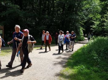

The best trails (101)

Trail Walking Guyancourt - ALBG Etang val d'or, minière - Photo
Walking 13.123
Km

Walking

Easy
(1)
Guyancourt, Ile-de-France, Yvelines, France
13.1 km | 16.1 km-effort
3h 41min
227 m
224 m
Yes
IreneProvost

Trail Walking Guyancourt - Etang de la Geneste - Photo
Walking 3.897
Km

Walking

Easy
Guyancourt, Ile-de-France, Yvelines, France
3.9 km | 4.9 km-effort
1h 11min
73 m
70 m
Yes
mallovon

Trail Walking Guyancourt - Rigole de Guyancourt - Photo
Walking 8.013
Km

Walking

Very easy
Guyancourt, Ile-de-France, Yvelines, France
8 km | 8.8 km-effort
1h 48min
59 m
59 m
Yes
Bouguyon

Trail Walking Guyancourt - Sortie Etang de la Geneste 07/06/2018 - Photo
Walking 10.679
Km

Walking

Medium
Guyancourt, Ile-de-France, Yvelines, France
10.7 km | 13.1 km-effort
3h 2min
179 m
181 m
Yes
microb

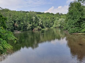
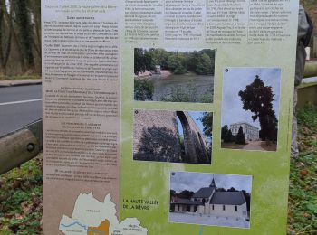
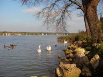
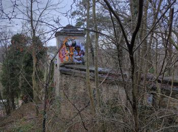
• Vallée de la Bièvre : Etang de la Geneste -Buc et ses arcades - Bois des Gonards et du Cerf-Volant.

Trail Mountain bike Guyancourt - St Quentin-Vaux de Cernay - Chevreuse - Photo
Mountain bike 53.142
Km

Mountain bike

Difficult
Guyancourt, Ile-de-France, Yvelines, France
53 km | 64 km-effort
3h 0min
817 m
818 m
Yes
tracegps

Trail Walking Guyancourt - La bievre - Photo
Walking 13.974
Km

Walking

Difficult
Guyancourt, Ile-de-France, Yvelines, France
14 km | 0 m-effort
3h 50min
0 m
0 m
No
huguesb

Trail Mountain bike Guyancourt - L'Homme Mort - forêt de Bois d'Arcy - Photo
Mountain bike 44.885
Km

Mountain bike

Difficult
Guyancourt, Ile-de-France, Yvelines, France
45 km | 52 km-effort
3h 0min
570 m
568 m
Yes
tracegps

Trail Running Guyancourt - Valdorienne 2009 - Photo
Running 48.785
Km

Running

Difficult
Guyancourt, Ile-de-France, Yvelines, France
49 km | 58 km-effort
5h 0min
722 m
723 m
Yes
tracegps

Trail Mountain bike Guyancourt - Valdorienne 2009 - Photo
Mountain bike 48.785
Km

Mountain bike

Difficult
Guyancourt, Ile-de-France, Yvelines, France
49 km | 58 km-effort
3h 30min
722 m
723 m
Yes
tracegps

Trail Walking Guyancourt - Valdorienne 2009 - Photo
Walking 48.785
Km

Walking

Medium
Guyancourt, Ile-de-France, Yvelines, France
49 km | 58 km-effort
8h 0min
722 m
723 m
Yes
tracegps

Trail Other activity Guyancourt - 2010-08-26 - 15h32m01 - Photo
Other activity 6.878
Km

Other activity

Very easy
Guyancourt, Ile-de-France, Yvelines, France
6.9 km | 7.4 km-effort
Unknown
41 m
40 m
No
cecemoto

Trail On foot Guyancourt - mardi L'après-midi Marche - Photo
On foot 11.529
Km

On foot

Easy
Guyancourt, Ile-de-France, Yvelines, France
11.5 km | 14.1 km-effort
3h 11min
190 m
188 m
Yes
CIE NPS

Trail Running Guyancourt - Minière bievre - Photo
Running 11.132
Km

Running

Medium
Guyancourt, Ile-de-France, Yvelines, France
11.1 km | 13.7 km-effort
1h 59min
190 m
190 m
Yes
huguesb

Trail Walking Guyancourt - 230210 - Photo
Walking 12.912
Km

Walking

Medium
Guyancourt, Ile-de-France, Yvelines, France
12.9 km | 15.8 km-effort
2h 46min
216 m
214 m
Yes
huguesb

Trail Walking Guyancourt - 220409 balade urbaine - Photo
Walking 2.574
Km

Walking

Easy
Guyancourt, Ile-de-France, Yvelines, France
2.6 km | 2.7 km-effort
36min
11 m
10 m
Yes
huguesb

Trail Car Guyancourt - Parcours LDM - Photo
Car 6.822
Km

Car

Guyancourt, Ile-de-France, Yvelines, France
6.8 km | 7.5 km-effort
14min
49 m
50 m
No
plr78

Trail Walking Guyancourt - lm 2 - Photo
Walking 6.366
Km

Walking

Very easy
Guyancourt, Ile-de-France, Yvelines, France
6.4 km | 7.1 km-effort
1h 36min
46 m
77 m
No
troisel

Trail Walking Guyancourt - Étangs du Val D’or - Photo
Walking 4.858
Km

Walking

Easy
Guyancourt, Ile-de-France, Yvelines, France
4.9 km | 5.5 km-effort
1h 9min
50 m
50 m
Yes
JLPIERSON

Trail Walking Guyancourt - Tour des étangs de la Minière  - Photo
Walking 9.248
Km

Walking

Guyancourt, Ile-de-France, Yvelines, France
9.2 km | 0 m-effort
2h 25min
0 m
0 m
Yes
JLPIERSON

Trail Walking Guyancourt - foret domaniale de versailles - Photo
Walking 21.04
Km

Walking

Easy
Guyancourt, Ile-de-France, Yvelines, France
21 km | 26 km-effort
4h 34min
343 m
338 m
Yes
jojo96

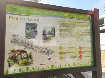
• depart etang de la miniere

20 trails displayed on 101

FREE GPS app for hiking

Logo SityTrail SityTrail

IGN / Geographical institutes

Download SityTrail from the App Store Download SityTrail from Google Play

Logo SityTrail SityTrail World

The world is yours!

Download SityTrail from the App Store Download SityTrail from Google Play Download SityTrail on Huawei AppGallery

Activities

Close
My subscriptions