La Faurie, Hautes-Alpes: Best trails, routes and walks

6 comments

La Faurie: Discover the best trails: 22 hiking trails and 12 bike and mountain-bike routes. All these trails, routes and outdoor activities are available in our SityTrail applications for smartphones and tablets.


The best trails (37)

Trail Walking La Faurie - R40   Les Marmites du Diable - Photo
Walking 5.872
Km
GUIDE+

Walking

Medium
(6)
La Faurie, Provence-Alpes-Côte d'Azur, Hautes-Alpes, France
5.9 km | 10.4 km-effort
2h 7min
341 m
341 m
Yes
Camping Les Rives du Lac

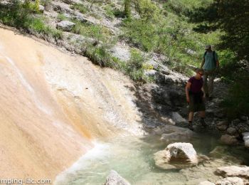
• A varied hike, starting along the pots (where you can swim), then crossing a forest before accessing a track. On the ...

Trail Walking La Faurie - SityTrail - SityTrail - La Vallette - Agnielles - Marmites du Diable - Photo
Walking 15.63
Km

Walking

Very difficult
La Faurie, Provence-Alpes-Côte d'Azur, Hautes-Alpes, France
15.6 km | 28 km-effort
6h 15min
893 m
891 m
Yes
kurt-vh

Trail Walking La Faurie - Les Marmites du Diable de Durbonas - Photo
Walking 6.424
Km

Walking

Very easy
La Faurie, Provence-Alpes-Côte d'Azur, Hautes-Alpes, France
6.4 km | 10.8 km-effort
4h 16min
331 m
316 m
Yes
Emelle

Trail Walking La Faurie - La Vallette - Agnielles - Marmites du Diable - Photo
Walking 15.629
Km

Walking

Difficult
La Faurie, Provence-Alpes-Côte d'Azur, Hautes-Alpes, France
15.6 km | 28 km-effort
4h 47min
892 m
889 m
Yes
jlv05

Trail Walking La Faurie - LA FAURIE-COL DE BAUMUGNE-30-07-2017 - Photo
Walking 17.246
Km

Walking

Difficult
La Faurie, Provence-Alpes-Côte d'Azur, Hautes-Alpes, France
17.2 km | 30 km-effort
8h 26min
949 m
949 m
Yes
RD78-38

Trail Walking La Faurie - pusteau - bas pass et retour par les coffies - Photo
Walking 9.302
Km

Walking

Medium
La Faurie, Provence-Alpes-Côte d'Azur, Hautes-Alpes, France
9.3 km | 13.1 km-effort
2h 24min
286 m
285 m
Yes
jcpistono

Trail Walking La Faurie - pusteaux - distillerie- preron - seilles - st -Jean - bois des faures - Pusteaux - Photo
Walking 7.057
Km

Walking

Very easy
La Faurie, Provence-Alpes-Côte d'Azur, Hautes-Alpes, France
7.1 km | 9.7 km-effort
1h 52min
195 m
193 m
Yes
jcpistono

Trail Walking La Faurie - autour du hameau les granges à Cousteau - Photo
Walking 14.021
Km

Walking

Difficult
La Faurie, Provence-Alpes-Côte d'Azur, Hautes-Alpes, France
14 km | 22 km-effort
6h 31min
620 m
579 m
No
Matamimi

Trail Mountain bike La Faurie - Pusteaux - col haute beaume - aureille - col de Montbrand - Photo
Mountain bike 22.516
Km

Mountain bike

Easy
La Faurie, Provence-Alpes-Côte d'Azur, Hautes-Alpes, France
23 km | 31 km-effort
1h 49min
657 m
656 m
Yes
jcpistono

Trail Walking La Faurie - sommet de laup - Photo
Walking 18.231
Km

Walking

Medium
La Faurie, Provence-Alpes-Côte d'Azur, Hautes-Alpes, France
18.2 km | 30 km-effort
7h 0min
898 m
897 m
Yes
gibello

Trail Mountain bike La Faurie - pusteaux - agnielles - col longeoire -  - Photo
Mountain bike 42.958
Km

Mountain bike

Easy
La Faurie, Provence-Alpes-Côte d'Azur, Hautes-Alpes, France
43 km | 60 km-effort
3h 42min
1278 m
1275 m
Yes
jcpistono

Trail Mountain bike La Faurie - aureille - col montbrand - col st andré - Photo
Mountain bike 22.845
Km

Mountain bike

Easy
La Faurie, Provence-Alpes-Côte d'Azur, Hautes-Alpes, France
23 km | 35 km-effort
2h 14min
920 m
922 m
Yes
jcpistono

Trail Mountain bike La Faurie - la rouye - Photo
Mountain bike 23.401
Km

Mountain bike

Easy
La Faurie, Provence-Alpes-Côte d'Azur, Hautes-Alpes, France
23 km | 35 km-effort
2h 6min
889 m
889 m
Yes
jcpistono

Trail Mountain bike La Faurie - cretes longeagne - Photo
Mountain bike 21.971
Km

Mountain bike

Easy
La Faurie, Provence-Alpes-Côte d'Azur, Hautes-Alpes, France
22 km | 33 km-effort
1h 49min
839 m
837 m
Yes
jcpistono

Trail Mountain bike La Faurie - Du côté du Buech - Photo
Mountain bike 33.16
Km

Mountain bike

Medium
La Faurie, Provence-Alpes-Côte d'Azur, Hautes-Alpes, France
33 km | 47 km-effort
3h 27min
1062 m
1070 m
Yes
tophe73

Trail Via ferrata La Faurie - Via ferrata sportive d'Agnielle - Photo
Via ferrata 0.907
Km

Via ferrata

Difficult
La Faurie, Provence-Alpes-Côte d'Azur, Hautes-Alpes, France
907 m | 1.9 km-effort
1h 0min
73 m
66 m
Yes
Dervalmarc

• DIFFICILE.130 de denivelé.Cotation AD.Exposition/est.Via difficile avec passages athlétiques Altitude de depart/828M:...

Trail Walking La Faurie - Marmites du diable  - Photo
Walking 9.183
Km

Walking

Difficult
La Faurie, Provence-Alpes-Côte d'Azur, Hautes-Alpes, France
9.2 km | 13.7 km-effort
4h 0min
334 m
347 m
No
bernard1959

Trail Walking La Faurie - 2022 09 29 La Faury G4 - Photo
Walking 13.75
Km

Walking

Easy
La Faurie, Provence-Alpes-Côte d'Azur, Hautes-Alpes, France
13.8 km | 21 km-effort
6h 43min
564 m
475 m
No
Jules Nury

Trail Walking La Faurie - la faurie - Photo
Walking 15.737
Km

Walking

Very difficult
La Faurie, Provence-Alpes-Côte d'Azur, Hautes-Alpes, France
15.7 km | 27 km-effort
6h 23min
850 m
850 m
Yes
Liebeaux

Trail Walking La Faurie - st apotre - Photo
Walking 8.619
Km

Walking

Difficult
La Faurie, Provence-Alpes-Côte d'Azur, Hautes-Alpes, France
8.6 km | 13.9 km-effort
3h 42min
428 m
297 m
No
madygay005

20 trails displayed on 37

FREE GPS app for hiking

Logo SityTrail SityTrail

IGN / Geographical institutes

Download SityTrail from the App Store Download SityTrail from Google Play

Logo SityTrail SityTrail World

The world is yours!

Download SityTrail from the App Store Download SityTrail from Google Play Download SityTrail on Huawei AppGallery

Activities

Close
My subscriptions