Hautes-Duyes, Alpes-de-Haute-Provence: Best trails, routes and walks

1 comments

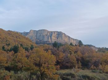
Hautes-Duyes: Discover the best trails: 15 hiking trails and 1 bike and mountain-bike routes. All these trails, routes and outdoor activities are available in our SityTrail applications for smartphones and tablets.


The best trails (16)

Trail Walking Hautes-Duyes - sommet Geruen et son pas - Photo
Walking 14.045
Km

Walking

Difficult
Hautes-Duyes, Provence-Alpes-Côte d'Azur, Alpes-de-Haute-Provence, France
14 km | 28 km-effort
7h 6min
1030 m
1033 m
Yes
nadd73

Trail Walking Hautes-Duyes - Crête de Géruën descente sud Est - Photo
Walking 11.567
Km

Walking

Difficult
Hautes-Duyes, Provence-Alpes-Côte d'Azur, Alpes-de-Haute-Provence, France
11.6 km | 22 km-effort
5h 18min
819 m
820 m
Yes
nadd73

Trail Walking Hautes-Duyes - geruen sentier des chamois  - Photo
Walking 10.985
Km

Walking

Very difficult
(1)
Hautes-Duyes, Provence-Alpes-Côte d'Azur, Alpes-de-Haute-Provence, France
11 km | 22 km-effort
7h 15min
791 m
793 m
Yes
Danielba

Trail Walking Hautes-Duyes - Les Brigands  - Photo
Walking 5.238
Km

Walking

Easy
Hautes-Duyes, Provence-Alpes-Côte d'Azur, Alpes-de-Haute-Provence, France
5.2 km | 8 km-effort
2h 6min
205 m
221 m
Yes
MarcVachet

Trail Walking Hautes-Duyes - AURIBEAU , col dAinac , Ainac , col S Antoine , pointe d Aiguille , pas de Gueruen n - Photo
Walking 14.887
Km

Walking

Difficult
Hautes-Duyes, Provence-Alpes-Côte d'Azur, Alpes-de-Haute-Provence, France
14.9 km | 25 km-effort
4h 57min
793 m
792 m
Yes
RobinMicheline

Trail Walking Hautes-Duyes - AURIBEAU,  Champ de Barras . col d Ainac o l s - Photo
Walking 13.711
Km

Walking

Difficult
Hautes-Duyes, Provence-Alpes-Côte d'Azur, Alpes-de-Haute-Provence, France
13.7 km | 24 km-effort
5h 12min
746 m
751 m
Yes
RobinMicheline

Trail Walking Hautes-Duyes - circuit des brigands - Photo
Walking 17.358
Km

Walking

Medium
Hautes-Duyes, Provence-Alpes-Côte d'Azur, Alpes-de-Haute-Provence, France
17.4 km | 26 km-effort
4h 43min
614 m
614 m
Yes
hueco

Trail Walking Hautes-Duyes - col stantoine - Photo
Walking 6.209
Km

Walking

Very easy
Hautes-Duyes, Provence-Alpes-Côte d'Azur, Alpes-de-Haute-Provence, France
6.2 km | 10.6 km-effort
2h 6min
383 m
163 m
No
jalien04

Trail Walking Hautes-Duyes - AURIBEAU Le tour de la roche des brigands - Photo
Walking 12.675
Km

Walking

Very easy
Hautes-Duyes, Provence-Alpes-Côte d'Azur, Alpes-de-Haute-Provence, France
12.7 km | 20 km-effort
4h 13min
586 m
583 m
Yes
RobinMicheline

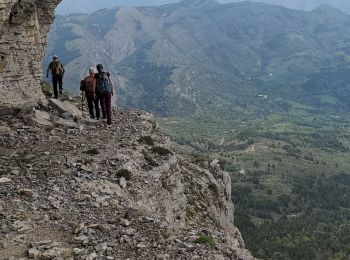
• 4,5 h 13 kms 600 m denivele A FAIRE

Trail Walking Hautes-Duyes - 20170617 CAF - Boucle Geruen depuis Col d'Ainac - Photo
Walking 31.691
Km

Walking

Difficult
Hautes-Duyes, Provence-Alpes-Côte d'Azur, Alpes-de-Haute-Provence, France
32 km | 49 km-effort
9h 37min
1311 m
1311 m
Yes
motardes04

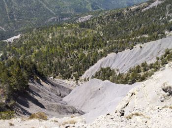
• Ca commence fort : la piste est défoncée, même avec le partner rehaussé ça touche ... vive les plaques de renfort sou...

Trail Walking Hautes-Duyes - ryujg - Photo
Walking 7.992
Km

Walking

Difficult
Hautes-Duyes, Provence-Alpes-Côte d'Azur, Alpes-de-Haute-Provence, France
8 km | 12.1 km-effort
2h 30min
309 m
311 m
Yes
Clo0413

Trail Walking Hautes-Duyes - circuit ainac projet  - Photo
Walking 13.002
Km

Walking

Medium
Hautes-Duyes, Provence-Alpes-Côte d'Azur, Alpes-de-Haute-Provence, France
13 km | 22 km-effort
4h 56min
653 m
661 m
Yes
gerin

Trail Walking Hautes-Duyes - La Pointe de l'Aiguille (Auribeau 04) - Photo
Walking 13.739
Km

Walking

Medium
Hautes-Duyes, Provence-Alpes-Côte d'Azur, Alpes-de-Haute-Provence, France
13.7 km | 24 km-effort
4h 14min
767 m
770 m
Yes
Clo0413

Trail Walking Hautes-Duyes - La Pointe d'Aiguille - Photo
Walking 13.76
Km

Walking

Medium
Hautes-Duyes, Provence-Alpes-Côte d'Azur, Alpes-de-Haute-Provence, France
13.8 km | 24 km-effort
4h 37min
759 m
760 m
Yes
Clo0413

Trail Walking Hautes-Duyes - Le Tour du Rocher des Brigands - Auribeau - Photo
Walking 11.335
Km

Walking

Very easy
Hautes-Duyes, Provence-Alpes-Côte d'Azur, Alpes-de-Haute-Provence, France
11.3 km | 16.7 km-effort
4h 44min
406 m
406 m
Yes
Clo0413

Trail Mountain bike Hautes-Duyes - Thoard/Les Brigands - Photo
Mountain bike 10.557
Km

Mountain bike

Medium
Hautes-Duyes, Provence-Alpes-Côte d'Azur, Alpes-de-Haute-Provence, France
10.6 km | 15.9 km-effort
1h 4min
398 m
407 m
Yes
remizzi

16 trails displayed on 16

FREE GPS app for hiking

Logo SityTrail SityTrail

IGN / Geographical institutes

Download SityTrail from the App Store Download SityTrail from Google Play

Logo SityTrail SityTrail World

The world is yours!

Download SityTrail from the App Store Download SityTrail from Google Play Download SityTrail on Huawei AppGallery

Activities

Close
My subscriptions