Majastres, Alpes-de-Haute-Provence: Best trails, routes and walks

Majastres: Discover the best trails: 11 hiking trails and 4 bike and mountain-bike routes. All these trails, routes and outdoor activities are available in our SityTrail applications for smartphones and tablets.


The best trails (14)

Trail Walking Majastres - Majastres Chiran - Photo
Walking 16.544
Km

Walking

Difficult
Majastres, Provence-Alpes-Côte d'Azur, Alpes-de-Haute-Provence, France
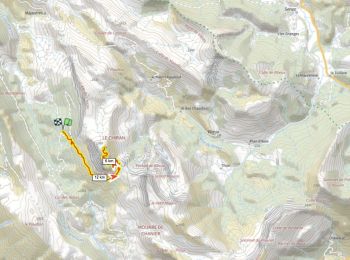
16.5 km | 29 km-effort
4h 54min
956 m
957 m
Yes
thierry13710

Trail Walking Majastres - Observatoire Mt Chiran 1900m D+600m - Photo
Walking 14.202
Km

Walking

Very difficult
Majastres, Provence-Alpes-Côte d'Azur, Alpes-de-Haute-Provence, France
14.2 km | 22 km-effort
5h 0min
587 m
589 m
Yes
ericberlin

Trail Walking Majastres - La Clue de la Melle - Photo
Walking 17.081
Km

Walking

Very easy
Majastres, Provence-Alpes-Côte d'Azur, Alpes-de-Haute-Provence, France
17.1 km | 27 km-effort
7h 53min
722 m
720 m
Yes
PITOUSSAINT

Trail Walking Majastres - Le Chiran - Photo
Walking 6.759
Km

Walking

Very easy
Majastres, Provence-Alpes-Côte d'Azur, Alpes-de-Haute-Provence, France
6.8 km | 12.2 km-effort
3h 2min
542 m
19 m
No
denis.petiaud

Trail Mountain bike Majastres - Majastre Chiran - Photo
Mountain bike 24.8
Km

Mountain bike

Medium
Majastres, Provence-Alpes-Côte d'Azur, Alpes-de-Haute-Provence, France
25 km | 36 km-effort
3h 31min
840 m
837 m
Yes
Bruno.r

Trail Walking Majastres - La Croix de la Melle - Le poil - Photo
Walking 11.042
Km

Walking

Difficult
Majastres, Provence-Alpes-Côte d'Azur, Alpes-de-Haute-Provence, France
11 km | 16.9 km-effort
3h 13min
389 m
598 m
No
Clo0413

Trail Walking Majastres - Majastres Coulet de Calasse Croix de la Melle - Photo
Walking 14.067
Km

Walking

Medium
Majastres, Provence-Alpes-Côte d'Azur, Alpes-de-Haute-Provence, France
14.1 km | 25 km-effort
3h 50min
785 m
784 m
Yes
Clo0413

Trail Walking Majastres - chiran - Photo
Walking 15.121
Km

Walking

Very easy
Majastres, Provence-Alpes-Côte d'Azur, Alpes-de-Haute-Provence, France
15.1 km | 29 km-effort
8h 0min
1058 m
1079 m
Yes
moreauchristian

Trail Mountain bike Majastres - [PAT] Rando Mont Chiran par Majastres - Photo
Mountain bike 30.654
Km

Mountain bike

Difficult
Majastres, Provence-Alpes-Côte d'Azur, Alpes-de-Haute-Provence, France
31 km | 49 km-effort
3h 2min
1347 m
1353 m
Yes
spiroudigne

Trail Mountain bike Majastres - Mont Chiran par Majastres - Photo
Mountain bike 30.654
Km

Mountain bike

Very easy
Majastres, Provence-Alpes-Côte d'Azur, Alpes-de-Haute-Provence, France
31 km | 49 km-effort
3h 2min
1346 m
1352 m
Yes
yobi

Trail Walking Majastres - Majastre - Chiran - Photo
Walking 6.739
Km

Walking

Very easy
Majastres, Provence-Alpes-Côte d'Azur, Alpes-de-Haute-Provence, France
6.7 km | 15.3 km-effort
3h 25min
816 m
106 m
No
madashop

Trail Walking Majastres - L'Hauteur depuis Majastres - Photo
Walking 11.905
Km

Walking

Very easy
Majastres, Provence-Alpes-Côte d'Azur, Alpes-de-Haute-Provence, France
11.9 km | 20 km-effort
4h 42min
642 m
637 m
Yes
motardes04

Trail Walking Majastres - 124-Le Chiran depuis Majastre - Photo
Walking 14.108
Km

Walking

Medium
Majastres, Provence-Alpes-Côte d'Azur, Alpes-de-Haute-Provence, France
14.1 km | 27 km-effort
5h 38min
985 m
996 m
Yes
dumotier

Trail Walking Majastres - ballade 06-08-2010 - Photo
Walking 2.089
Km

Walking

Very easy
Majastres, Provence-Alpes-Côte d'Azur, Alpes-de-Haute-Provence, France
2.1 km | 2.7 km-effort
Unknown
1 m
170 m
No
pupetmaster

14 trails displayed on 14

FREE GPS app for hiking

Logo SityTrail SityTrail

IGN / Geographical institutes

Download SityTrail from the App Store Download SityTrail from Google Play

Logo SityTrail SityTrail World

The world is yours!

Download SityTrail from the App Store Download SityTrail from Google Play Download SityTrail on Huawei AppGallery

Activities

Close
My subscriptions