Ferrère, Hautespyrenees: Best trails, routes and walks

Ferrère: Discover the best trails: 59 hiking trails. All these trails, routes and outdoor activities are available in our SityTrail applications for smartphones and tablets.


The best trails (62)

Trail Walking Ferrère - montagne d'Areng depuis la piste forestière après Férrères - Photo
Walking 11.722
Km

Walking

Difficult
Ferrère, Occitania, Hautespyrenees, France
11.7 km | 24 km-effort
7h 44min
923 m
923 m
Yes
chrisgps

Trail Walking Ferrère - pic de Douly en boucle depuis Ferrère  - Photo
Walking 12.385
Km
GUIDE

Walking

Medium
Ferrère, Occitania, Hautespyrenees, France
12.4 km | 25 km-effort
5h 56min
935 m
926 m
Yes
lhomme.ph

Trail Walking Ferrère - Le Cournudère en boucle depuis Bordes de Saube - Photo
Walking 17.205
Km

Walking

Medium
Ferrère, Occitania, Hautespyrenees, France
17.2 km | 34 km-effort
6h 35min
1255 m
1256 m
Yes
Rouzier

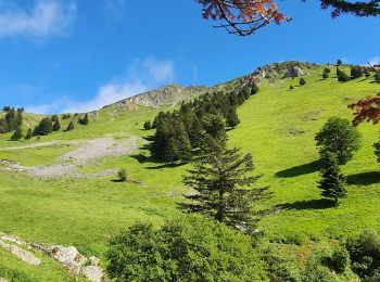
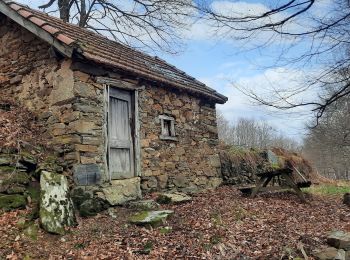
• Bordes de Saubé, ruisseau du Pin, ancienne cabane du Pin, nouvelle cabane du Pin, montagne du Pin, sommet du Peberé, ...

Trail Walking Ferrère - Ferrère  (65) - Port de Balès  (1755). - Photo
Walking 10.066
Km

Walking

Medium
Ferrère, Occitania, Hautespyrenees, France
10.1 km | 16.3 km-effort
3h 29min
471 m
470 m
Yes
AndreLACOMBE

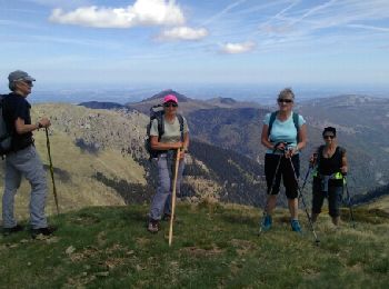
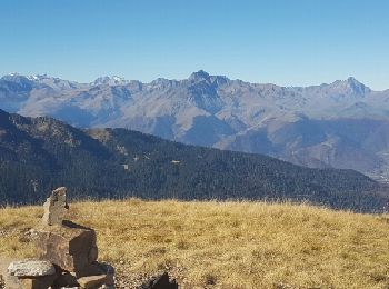
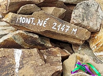
• Ascension vers le Mont Né (2147 m) et retour par le Port de Pierrefite.

Trail Walking Ferrère - soum de templa - Photo
Walking 16.698
Km

Walking

Medium
Ferrère, Occitania, Hautespyrenees, France
16.7 km | 32 km-effort
5h 21min
1176 m
1175 m
Yes
Jacqueline Vandergheynst

Trail Walking Ferrère - Marrougne en boucle depuis Ferrère  - Photo
Walking 9.934
Km
GUIDE

Walking

Very difficult
Ferrère, Occitania, Hautespyrenees, France
9.9 km | 20 km-effort
5h 59min
792 m
792 m
Yes
lhomme.ph

Trail Walking Ferrère - Pic Douly en boucle descente vers Ourde Acc - Photo
Walking 13.704
Km

Walking

Medium
Ferrère, Occitania, Hautespyrenees, France
13.7 km | 27 km-effort
5h 25min
1003 m
1002 m
Yes
Jeanne Pene

Trail Walking Ferrère - Le port de Bales - Photo
Walking 7.862
Km

Walking

Difficult
Ferrère, Occitania, Hautespyrenees, France
7.9 km | 13.8 km-effort
6h 2min
445 m
445 m
Yes
bliguet

Trail Walking Ferrère - cap Nesté depuis la Barousse  - Photo
Walking 9.153
Km
GUIDE

Walking

Medium
Ferrère, Occitania, Hautespyrenees, France
9.2 km | 19.3 km-effort
6h 46min
763 m
758 m
Yes
lhomme.ph

Trail Walking Ferrère - Douly depuis Ourde avec Jeanne - Photo
Walking 7.524
Km

Walking

Easy
Ferrère, Occitania, Hautespyrenees, France
7.5 km | 17.7 km-effort
2h 53min
990 m
81 m
No
(null) (null)2d73a32012fbb405f85d3457f10971c41

Trail Walking Ferrère - Remplace Mont NE - Photo
Walking 5.839
Km

Walking

Ferrère, Occitania, Hautespyrenees, France
5.8 km | 10.6 km-effort
2h 4min
309 m
494 m
No
(null) (null)2d73a32012fbb405f85d3457f10971c41

Trail Walking Ferrère - Le mont sec depuis Saoube  - Photo
Walking 12.251
Km
GUIDE

Walking

Medium
Ferrère, Occitania, Hautespyrenees, France
12.3 km | 22 km-effort
6h 17min
717 m
714 m
Yes
lhomme.ph

Trail Walking Ferrère - Le Montious en boucles (2) - Photo
Walking 15.043
Km

Walking

Medium
Ferrère, Occitania, Hautespyrenees, France
15 km | 28 km-effort
7h 1min
963 m
968 m
Yes
chrisgps

Trail Walking Ferrère - Mont Né- lac Bareille - pic du Lion par les crêtes  - Photo
Walking 17.189
Km
GUIDE

Walking

Medium
Ferrère, Occitania, Hautespyrenees, France
17.2 km | 30 km-effort
4h 40min
962 m
965 m
Yes
antignacs

Trail Walking Ferrère - Mont ne et lac de Bareilles - Photo
Walking 10.512
Km

Walking

Ferrère, Occitania, Hautespyrenees, France
10.5 km | 17.9 km-effort
5h 8min
555 m
558 m
Yes
mhcombes

Trail Walking Ferrère - mont Las  - Photo
Walking 8.209
Km

Walking

Difficult
Ferrère, Occitania, Hautespyrenees, France
8.2 km | 21 km-effort
6h 1min
1062 m
607 m
No
martoche

Trail Walking Ferrère - Montagne d'Areng - Photo
Walking 10.619
Km

Walking

Medium
Ferrère, Occitania, Hautespyrenees, France
10.6 km | 22 km-effort
4h 4min
862 m
853 m
Yes
dawed311

Trail Walking Ferrère - Pic du Mont Aspet - Photo
Walking 12.987
Km

Walking

Medium
Ferrère, Occitania, Hautespyrenees, France
13 km | 24 km-effort
3h 24min
848 m
842 m
Yes
dawed311

Trail Walking Ferrère - Mont Aspet cap nestes  - Photo
Walking 7.956
Km

Walking

Very easy
Ferrère, Occitania, Hautespyrenees, France
8 km | 12 km-effort
2h 57min
281 m
373 m
No
martoche

Trail Walking Ferrère - le mont Aspet en boucle  depuis Lanère - Photo
Walking 13.626
Km
GUIDE

Walking

Medium
Ferrère, Occitania, Hautespyrenees, France
13.6 km | 26 km-effort
7h 33min
958 m
958 m
Yes
lhomme.ph

20 trails displayed on 62

FREE GPS app for hiking

Logo SityTrail SityTrail

IGN / Geographical institutes

Download SityTrail from the App Store Download SityTrail from Google Play

Logo SityTrail SityTrail World

The world is yours!

Download SityTrail from the App Store Download SityTrail from Google Play Download SityTrail on Huawei AppGallery

Activities

Close
My subscriptions