Home
World
NEW
Premium
Shop
Trails
Articles
Help and support
Français
English
Nederlands
Español
Italiano
Deutsch
Log in
Home
World
Premium
Shop
Trails
Articles
Help and support
SityTrail
>
Points of interest
>
Point 17
SityTrail
>
Points of interest
>
Point 17
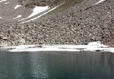
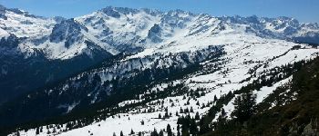
Point 17
Description
Photos
Point 17 can be discovered in the following trails...
Noiraude
Lacs de la Valloire
Walking
Difficult
Le Haut-Bréda, Auvergne-Rhône-Alpes, Isère, France
16.1 km | 36 km-effort
7h 48min
Yes
Noiraude
User
©
OpenStreetMap
contributors
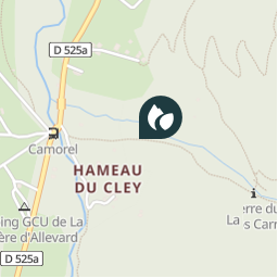
Positioning
Country:
France
Region :
Auvergne-Rhône-Alpes
Department/Province :
Isère
Municipality :
Le Haut-Bréda
Location:
La Ferrière
Positioning
45.29661966 / 6.082285129999946
Creation date :
2018-04-11 12:21:13.603
Updated on
2018-04-11 12:21:13.603
(0 Reviews)
Comments
Please log in to post a review or rate the element
Points of interest nearby
micleo66
Arrivée Relais 1
LE HAUT-BRÉDA
patjobou
Point 3
THEYS
tracegps
GC164JT
LE HAUT-BRÉDA
tracegps
GC164JT
LE HAUT-BRÉDA
tracegps
GC164JT
LE HAUT-BRÉDA
tracegps
GC164JT
LE HAUT-BRÉDA
tracegps
GC164JT
LE HAUT-BRÉDA
tracegps
GC164JT
LE HAUT-BRÉDA
Close
My subscriptions