Home
World
NEW
Premium
Shop
Trails
Articles
Help and support
Français
English
Nederlands
Español
Italiano
Deutsch
Log in
Home
World
Premium
Shop
Trails
Articles
Help and support
SityTrail
>
Points of interest
>
Point 11
SityTrail
>
Points of interest
>
Point 11
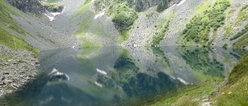
Point 11
Description
Photos
Point 11 can be discovered in the following trails...
Didou2626
A-R prapoutel-lac de crop
Walking
Medium
Les Adrets, Auvergne-Rhône-Alpes, Isère, France
16.6 km | 28 km-effort
4h 44min
Yes
Didou2626
User
©
OpenStreetMap
contributors
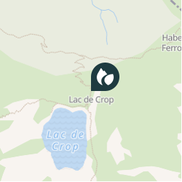
Positioning
Country:
France
Region :
Auvergne-Rhône-Alpes
Department/Province :
Isère
Municipality :
Sainte-Agnès
Location:
Unknown
Positioning
45.20982262 / 5.98892046
Creation date :
2018-04-10 14:13:03.455
Updated on
2018-04-10 14:13:03.455
(0 Reviews)
Comments
Please log in to post a review or rate the element
Points of interest nearby
Bushiben
Arrivée au col.
SAINTE-AGNÈS
tracegps
GC1ER6A
SAINTE-AGNÈS
tracegps
GC1ER6A
SAINTE-AGNÈS
tracegps
GC1ER6A
SAINTE-AGNÈS
tracegps
GC1ER6A
SAINTE-AGNÈS
tracegps
GC1ER6A
SAINTE-AGNÈS
tracegps
GC1ER6A
SAINTE-AGNÈS
tracegps
GC1ER6A
SAINTE-AGNÈS
Close
My subscriptions