Home
World
NEW
Premium
Shop
Trails
Articles
Help and support
Français
English
Nederlands
Español
Italiano
Deutsch
Log in
Home
World
Premium
Shop
Trails
Articles
Help and support
SityTrail
>
Points of interest
>
GCY32E
SityTrail
>
Points of interest
>
GCY32E
GCY32E
Description
Land-is Joux-Plane by daniel t
Photos
GCY32E can be discovered in the following trails...
tracegps
Pierre-Larron depuis La Charmette
Running
Difficult
Les Avanchers-Valmorel, Auvergne-Rhône-Alpes, Savoy, France
7.5 km | 13.7 km-effort
2h 30min
Yes
tracegps
User
©
OpenStreetMap
contributors
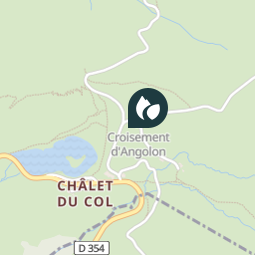
Positioning
Country:
France
Region :
Auvergne-Rhône-Alpes
Department/Province :
Upper Savoy
Municipality :
Verchaix
Location:
Unknown
Positioning
46.13125 / 6.712883
Creation date :
2018-04-09 12:21:58.728
Updated on
2018-04-09 12:21:58.728
(0 Reviews)
Comments
Please log in to post a review or rate the element
Points of interest nearby
tracegps
GCY32E
VERCHAIX
tracegps
GCY32E
VERCHAIX
tracegps
GCY32E
VERCHAIX
tracegps
GCY32E
VERCHAIX
tracegps
GCY32E
VERCHAIX
tracegps
GCY32E
VERCHAIX
tracegps
GCY32E
VERCHAIX
tracegps
GCY32E
VERCHAIX
Close
My subscriptions