Home
World
NEW
Premium
Shop
Trails
Articles
Help and support
Français
English
Nederlands
Español
Italiano
Deutsch
Log in
Home
World
Premium
Shop
Trails
Articles
Help and support
SityTrail
>
Points of interest
>
Gite
SityTrail
>
Points of interest
>
Gite
Gite
Description
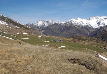
Gite d'étape 1610m
Photos
Gite can be discovered in the following trails...
tracegps
Le Plateau de Saugué 1610m
Walking
Medium
Gavarnie-Gèdre, Occitania, Hautespyrenees, France
11.1 km | 17.9 km-effort
3h 30min
Yes
tracegps
User
©
OpenStreetMap
contributors
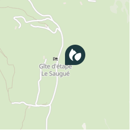
Positioning
Country:
France
Region :
Occitania
Department/Province :
Hautespyrenees
Municipality :
Gavarnie-Gèdre
Location:
Gèdre
Positioning
42.768266379 / -0.00512812
Creation date :
2018-04-09 11:32:49.428
Updated on
2018-04-09 11:32:49.428
(0 Reviews)
Comments
Please log in to post a review or rate the element
Points of interest nearby
laolong
Gite de Saugué
GAVARNIE-GÈDRE
tracegps
1610-Plate
GAVARNIE-GÈDRE
tracegps
GR10
GAVARNIE-GÈDRE
tracegps
Bareilles
GAVARNIE-GÈDRE
laolong
Turon de Tesy
GAVARNIE-GÈDRE
laolong
Croupe de Pouey-Boucou
GAVARNIE-GÈDRE
tracegps
D128
GAVARNIE-GÈDRE
laolong
Refuge de la Grange de Holle
GAVARNIE-GÈDRE
Close
My subscriptions