Trail Cycle Hauts de Bienne - Morez-Mijoux - Photo
 lbguigui
lbguigui

User

© OpenStreetMap contributors
Length
Length
36 km
Max alt
Max alt
1208 m
Uphill gradient
Uphill gradient
864 m
Km-Effort
Km-Effort  
47 km
Min alt
Min alt
696 m
Downhill gradient
Downhill gradient
570 m
Boucle
Boucle
No
Creation date :
2019-01-15 12:44:28.087
Updated on :
2019-01-15 12:44:28.087

(0 Reviews)

Cycle
Cycle
2h42
Difficulty : Difficult

Scan this QR Code to open this trail in the SityTrail application

FREE GPS app for hiking

Logo SityTrail SityTrail

IGN / Geographical institutes

Download SityTrail from the App Store Download SityTrail from Google Play

Logo SityTrail SityTrail World

The world is yours!

Download SityTrail from the App Store Download SityTrail from Google Play Download SityTrail on Huawei AppGallery

About

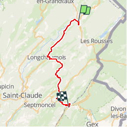
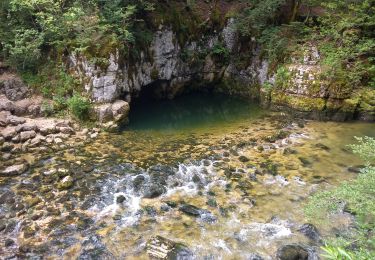
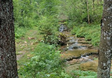
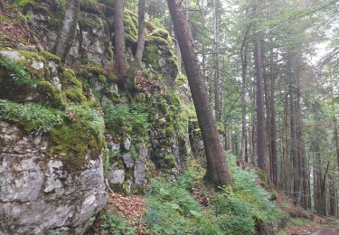
Trail Cycle of 36 km to be discovered at Bourgogne-Franche-Comté, Jura, Hauts de Bienne. This trail is proposed by lbguigui.

Description

Morez-Mijoux

Elevation profile

Positioning

Country:
France
Region :
Bourgogne-Franche-Comté
Department/Province :
Jura
Municipality :
Hauts de Bienne
Location:
Morez
Start:(UTM)
271481 ; 5157269 (32T) N.

Trails nearby

Trail Snowshoes Les Rousses - Lac des Rousses  - Photo
Snowshoes
nfranche

Snowshoes

Medium
(1)
Les Rousses, Bourgogne-Franche-Comté, Jura, France
13.8 km | 18.4 km-effort
4h 15min
Yes
Trail Walking Bellefontaine - Lac de Bellefontaine er lac des Mortes . - Photo
Walking
nana1643

Walking

Easy
Bellefontaine, Bourgogne-Franche-Comté, Jura, France
9.5 km | 11.5 km-effort
2h 33min
Yes
Trail Walking Les Rousses - lac des rousses . roche blanche . fort du risoux - Photo
Walking
GUIDE
stef789

Walking

Easy
Les Rousses, Bourgogne-Franche-Comté, Jura, France
10.2 km | 14.1 km-effort
4h 20min
Yes
Trail Walking Les Rousses - Lac
Walking
Mady Lambert

Walking

Difficult
Les Rousses, Bourgogne-Franche-Comté, Jura, France
27 km | 37 km-effort
3h 2min
No
Trail Walking Hauts de Bienne - Le Trou Bleu 11.7.23 - Photo
Walking
GUIDE
fredetpascale

Walking

Easy
Hauts de Bienne, Bourgogne-Franche-Comté, Jura, France
3.9 km | 5.3 km-effort
1h 15min
Yes
Trail Walking Bellefontaine - Pichonnier-Peraillet- village par l'Évalude - Photo
Walking
Mady Lambert

Walking

Difficult
Bellefontaine, Bourgogne-Franche-Comté, Jura, France
5.4 km | 7.5 km-effort
1h 53min
Yes
Trail Walking Bellefontaine - Des lacs de Bellefontaine vers le belvédère de la roche Bernard. - Photo
Walking
fizz1212

Walking

Difficult
Bellefontaine, Bourgogne-Franche-Comté, Jura, France
5.8 km | 8.7 km-effort
1h 53min
Yes
Trail Bicycle tourism Les Rousses - LES ROUSSES - SAINT CLAUDE  - Photo
Bicycle tourism
jean-marie.parachini

Bicycle tourism

Difficult
Les Rousses, Bourgogne-Franche-Comté, Jura, France
69 km | 88 km-effort
6h 15min
No
Trail Bicycle tourism Les Rousses - LES ROUSSES - PARCOURS EST VERS LA SUISSE  - Photo
Bicycle tourism
jean-marie.parachini

Bicycle tourism

Difficult
Les Rousses, Bourgogne-Franche-Comté, Jura, France
67 km | 85 km-effort
7h 18min
Yes


Close
My subscriptions