


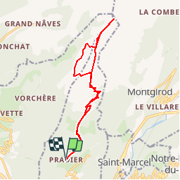
Pradier 73 La Quermoz par les chalets de la Faverge

ARPF
User

Length
14.9 km

Max alt
2275 m

Uphill gradient
1032 m
Km-Effort
29 km

Min alt
1287 m

Downhill gradient
1034 m
Boucle
Yes
Creation date :
2019-01-15 13:06:10.358
Updated on :
2019-01-15 13:06:10.358
5h43
Difficulty : Medium

FREE GPS app for hiking
 SityTrail
IGN / Geographical institutes
SityTrail Plus
The world is yours!
About
Trail Walking of 14.9 km to be discovered at Auvergne-Rhône-Alpes, Savoy, Hautecour. This trail is proposed by ARPF.
Positioning
Country:
France
Region :
Auvergne-Rhône-Alpes
Department/Province :
Savoy
Municipality :
Hautecour
Location:
Unknown
Start:(Dec)
Start:(UTM)
307765 ; 5042854 (32T) N.
Comments