


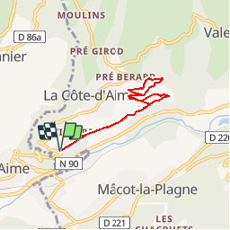
La Sciaz par le sentier des vignes

gilsep
User

Length
6.2 km

Max alt
972 m

Uphill gradient
193 m
Km-Effort
8.8 km

Min alt
783 m

Downhill gradient
194 m
Boucle
Yes
Creation date :
2019-01-15 13:06:47.063
Updated on :
2019-01-15 13:06:47.063
1h42
Difficulty : Easy

FREE GPS app for hiking
 SityTrail
IGN / Geographical institutes
SityTrail Plus
The world is yours!
About
Trail Walking of 6.2 km to be discovered at Auvergne-Rhône-Alpes, Savoy, La Plagne-Tarentaise. This trail is proposed by gilsep.
Description
Une promenade facile balisée en jaune à travers les vignes au-dessus d'Aime et jusqu'à La Sciaz.
Il faut prendre la route de la Côte d'Aime et s'engager dans le petit chemin droite.
Positioning
Country:
France
Region :
Auvergne-Rhône-Alpes
Department/Province :
Savoy
Municipality :
La Plagne-Tarentaise
Location:
La Côte-d'Aime
Start:(Dec)
Start:(UTM)
317475 ; 5047765 (32T) N.
Comments