Trail Walking Montgenèvre - Les crêtes du Chalvet - Photo
 amiral13
amiral13

User GUIDE

© OpenStreetMap contributors
Length
Length
12 km
Max alt
Max alt
2670 m
Uphill gradient
Uphill gradient
834 m
Km-Effort
Km-Effort  
23 km
Min alt
Min alt
1850 m
Downhill gradient
Downhill gradient
833 m
Boucle
Boucle
Yes
Creation date :
2018-08-03 21:06:03.467
Updated on :
2018-08-03 21:06:03.504

(0 Reviews)

Walking
Walking
6h03
Difficulty : Medium

Scan this QR Code to open this trail in the SityTrail application

FREE GPS app for hiking

Logo SityTrail SityTrail

IGN / Geographical institutes

Download SityTrail from the App Store Download SityTrail from Google Play

Logo SityTrail SityTrail World

The world is yours!

Download SityTrail from the App Store Download SityTrail from Google Play Download SityTrail on Huawei AppGallery

About

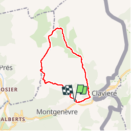
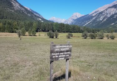
Trail Walking of 12 km to be discovered at Provence-Alpes-Côte d'Azur, Hautes-Alpes, Montgenèvre. This trail is proposed by amiral13.

Description

un très beau circuit si l'on fait abstraction de la remontée des pistes jusqu'à la station du Chalvet. A partir de la un très beau parcours en crête suivi d'un retour par l'idyllique vallon des baisses.
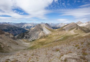
de magnifiques points de vue sur les écrins et le Chaberton.

Elevation profile

Photos

Positioning

Country:
France
Region :
Provence-Alpes-Côte d'Azur
Department/Province :
Hautes-Alpes
Municipality :
Montgenèvre
Location:
Unknown
Start:(UTM)
320933 ; 4978237 (32T) N.

Trails nearby

Trail Walking Montgenèvre - Le Chaberton - Photo
Walking
GUIDE
R@ph

Walking

Difficult
(2)
Montgenèvre, Provence-Alpes-Côte d'Azur, Hautes-Alpes, France
15.4 km | 32 km-effort
6h 15min
Yes
Trail Mountain bike Val-des-Prés - Montgenèvre et col de la Lauze - Photo
Mountain bike
tracegps

Mountain bike

Very difficult
(1)
Val-des-Prés, Provence-Alpes-Côte d'Azur, Hautes-Alpes, France
38 km | 57 km-effort
3h 30min
Yes
Trail Walking Montgenèvre - le mont Chaberton - Photo
Walking
GUIDE
amiral13

Walking

Medium
(1)
Montgenèvre, Provence-Alpes-Côte d'Azur, Hautes-Alpes, France
16.4 km | 33 km-effort
8h 48min
Yes
Trail Walking Val-des-Prés - le Chenaillet et le grand charvia - Photo
Walking
GUIDE
amiral13

Walking

Medium
Val-des-Prés, Provence-Alpes-Côte d'Azur, Hautes-Alpes, France
11.3 km | 19.5 km-effort
4h 17min
No
Trail Walking Montgenèvre - le sommet de Château Jouan et le fort de Janus - Photo
Walking
GUIDE
amiral13

Walking

Difficult
Montgenèvre, Provence-Alpes-Côte d'Azur, Hautes-Alpes, France
13.8 km | 24 km-effort
4h 15min
Yes
Trail Mountain bike Montgenèvre - tour de montgenevre - Photo
Mountain bike
Vincentetourmy

Mountain bike

Very difficult
(1)
Montgenèvre, Provence-Alpes-Côte d'Azur, Hautes-Alpes, France
32 km | 50 km-effort
3h 15min
Yes
Trail Walking Montgenèvre - Mont Chaberton (Hautes-Alpes) - Photo
Walking
toutankhcarton

Walking

Difficult
Montgenèvre, Provence-Alpes-Côte d'Azur, Hautes-Alpes, France
15 km | 32 km-effort
5h 7min
Yes
Trail Walking Montgenèvre - Tête des Fournéous - Photo
Walking
astro45

Walking

Difficult
Montgenèvre, Provence-Alpes-Côte d'Azur, Hautes-Alpes, France
4.5 km | 12.1 km-effort
2h 44min
No
Trail Walking Val-des-Prés - Briançon le Vacher - Photo
Walking
mimosa55

Walking

Medium
Val-des-Prés, Provence-Alpes-Côte d'Azur, Hautes-Alpes, France
6.7 km | 8.1 km-effort
2h 30min
No


Close
My subscriptions