


CHAMPAGNY-EN-VANOISE (73).

AndreLACOMBE
User
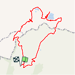

Length
12.4 km

Max alt
2437 m

Uphill gradient
548 m
Km-Effort
19.7 km

Min alt
1951 m

Downhill gradient
552 m
Boucle
Yes
Creation date :
2019-01-15 13:12:31.939
Updated on :
2019-01-15 13:12:31.939
6h26
Difficulty : Easy

FREE GPS app for hiking
 SityTrail
IGN / Geographical institutes
SityTrail Plus
The world is yours!
About
Trail Walking of 12.4 km to be discovered at Auvergne-Rhône-Alpes, Savoy, Champagny-en-Vanoise. This trail is proposed by AndreLACOMBE.
Description
Lac des Blanchets. Boucle depuis l'arrivée de la télécabine
Positioning
Country:
France
Region :
Auvergne-Rhône-Alpes
Department/Province :
Savoy
Municipality :
Champagny-en-Vanoise
Location:
Unknown
Start:(Dec)
Start:(UTM)
319805 ; 5037985 (32T) N.
Comments