


Bozon-Tufs blancs

cron
User
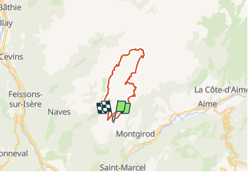

Length
20 km

Max alt
2323 m

Uphill gradient
874 m
Km-Effort
32 km

Min alt
1863 m

Downhill gradient
881 m
Boucle
Yes
Creation date :
2019-01-15 13:13:45.674
Updated on :
2019-01-15 13:13:45.674
6h37
Difficulty : Difficult

FREE GPS app for hiking
 SityTrail
IGN / Geographical institutes
SityTrail Plus
The world is yours!
About
Trail Walking of 20 km to be discovered at Auvergne-Rhône-Alpes, Savoy, Aime-la-Plagne. This trail is proposed by cron.
Positioning
Country:
France
Region :
Auvergne-Rhône-Alpes
Department/Province :
Savoy
Municipality :
Aime-la-Plagne
Location:
Unknown
Start:(Dec)
Start:(UTM)
309452 ; 5046266 (32T) N.
Comments