


180719 aoste Eaux rousses

stef789
User GUIDE
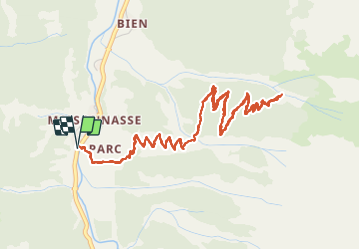

Length
7.4 km

Max alt
2194 m

Uphill gradient
514 m
Km-Effort
14.3 km

Min alt
1660 m

Downhill gradient
514 m
Boucle
Yes
Creation date :
2019-01-15 13:15:21.218
Updated on :
2019-01-15 13:15:21.218
2h30
Difficulty : Unknown

FREE GPS app for hiking
 SityTrail
IGN / Geographical institutes
SityTrail Plus
The world is yours!
About
Trail Walking of 7.4 km to be discovered at Aosta Valley, Unknown, Valsavarenche. This trail is proposed by stef789.
Positioning
Country:
Italy
Region :
Aosta Valley
Department/Province :
Unknown
Municipality :
Valsavarenche
Location:
Unknown
Start:(Dec)
Start:(UTM)
360165 ; 5047462 (32T) N.
Comments