


CHAMPAGNY-EN-VANOISE (73).

AndreLACOMBE
User

Length
17 km

Max alt
2374 m

Uphill gradient
855 m
Km-Effort
28 km

Min alt
1559 m

Downhill gradient
869 m
Boucle
Yes
Creation date :
2019-01-15 13:17:21.776
Updated on :
2019-01-15 13:17:21.776
7h43
Difficulty : Medium

FREE GPS app for hiking
 SityTrail
IGN / Geographical institutes
SityTrail Plus
The world is yours!
About
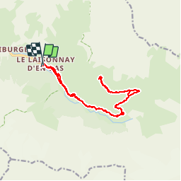
Trail Walking of 17 km to be discovered at Auvergne-Rhône-Alpes, Savoy, Champagny-en-Vanoise. This trail is proposed by AndreLACOMBE.
Description
Lac des Echines. Au départ du Laisonnay, direction col du Palet jusqu'au chalet des Gardes puis chalet des Barmés. Retour même itinéraire.
Positioning
Country:
France
Region :
Auvergne-Rhône-Alpes
Department/Province :
Savoy
Municipality :
Champagny-en-Vanoise
Location:
Unknown
Start:(Dec)
Start:(UTM)
326075 ; 5035215 (32T) N.
Comments