Trail Mountain bike Plaine - Les Brimbelles 2005 - 60km - Photo

Les Brimbelles 2005 - 60km

 tracegps
tracegps

User

© OpenStreetMap contributors
Length
Length
58 km
Max alt
Max alt
910 m
Uphill gradient
Uphill gradient
1715 m
Km-Effort
Km-Effort  
81 km
Min alt
Min alt
443 m
Downhill gradient
Downhill gradient
1709 m
Boucle
Boucle
Yes
Creation date :
2014-12-10 00:00:00.0
Updated on :
2014-12-10 00:00:00.0

(0 Reviews)

Mountain bike
Mountain bike
4h10
Difficulty : Very difficult

Scan this QR Code to open this trail in the SityTrail application

FREE GPS app for hiking

Logo SityTrail SityTrail

IGN / Geographical institutes

Download SityTrail from the App Store Download SityTrail from Google Play

Logo SityTrail SityTrail World

The world is yours!

Download SityTrail from the App Store Download SityTrail from Google Play Download SityTrail on Huawei AppGallery

About

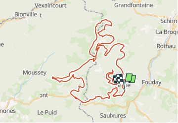
Trail Mountain bike of 58 km to be discovered at Grand Est, Bas-Rhin, Plaine. This trail is proposed by tracegps.

Description

Monsieur Météo avait annoncé un temps épouvantable pour ce dimanche 21 août 2005 (pluie continue, orages, etc...). Avec un départ à 8h00, je n'ai finalement pas été mouillé et je n'ai jamais sortie le coupe-vent. Comme chaque année, ce rendez-vous est un incontournable, le tracé est toujours beau avec une mention spéciale pour la première boucle tracée dans les Hautes Chaumes avant de rejoindre le Col du Prayé. Globalement le parcours était plus roulant que l'année précédente, mais félicitations aux organisateurs qui restent inventifs à chaque nouvelles édition. Très belle randonnée en moyenne montagne de 60 Kms. Ce parcours est destiné aux vététistes aguerris. Plaine - Maison Forestière de Salm - Etang du Coucou - Col du Prayé par les Hautes-Chaumes - Route Forestière de la Maxe - La Haute Loge - Trou du Cuveau - Chemin des Crasses - Col du Hantz - Bois Royal - Champenay - Plaine.

Elevation profile

Positioning

Country:
France
Region :
Grand Est
Department/Province :
Bas-Rhin
Municipality :
Plaine
Location:
Unknown
Start:(UTM)
362964 ; 5364083 (32U) N.

Trails nearby

Trail Walking La Broque - 2013-05-18 Marche Ruines de Salm - Photo
Walking
GUIDE
holtzv

Walking

Very easy
(2)
La Broque, Grand Est, Bas-Rhin, France
6.9 km | 10.6 km-effort
2h 38min
Yes
Trail Walking Plaine - Champenay - Photo
Walking
VacheKiri67

Walking

Medium
(1)
Plaine, Grand Est, Bas-Rhin, France
17.9 km | 27 km-effort
6h 30min
Yes
Trail Walking La Broque - 2023-05-13 Marche Sentier des Passeurs Salm - Photo
Walking
GUIDE
holtzv

Walking

Medium
La Broque, Grand Est, Bas-Rhin, France
25 km | 36 km-effort
7h 49min
Yes
Trail Walking Solbach - Rando Solbach  - Photo
Walking
enciloti

Walking

Medium
(1)
Solbach, Grand Est, Bas-Rhin, France
4.6 km | 6.6 km-effort
1h 29min
Yes
Trail Horseback riding Barembach - 2022-10-30 Journée Rothau Struthof Serva Perheux - Photo
Horseback riding
GUIDE
holtzv

Horseback riding

Difficult
Barembach, Grand Est, Bas-Rhin, France
25 km | 37 km-effort
5h 31min
Yes
Trail Walking Fouday - HOTEL JULIEN v - Photo
Walking
valeureux

Walking

Easy
(1)
Fouday, Grand Est, Bas-Rhin, France
7.8 km | 10.5 km-effort
2h 20min
Yes
Trail Walking La Broque - Etang du Coucou - Château de Salm - Chatte pendue - Haute Loge - Chapelle Bipierre - Photo
Walking
Bart2015

Walking

Very difficult
La Broque, Grand Est, Bas-Rhin, France
19.9 km | 29 km-effort
6h 32min
Yes
Trail Walking Plaine - Fouday - Photo
Walking
PhilWas

Walking

Difficult
Plaine, Grand Est, Bas-Rhin, France
10.4 km | 14.4 km-effort
2h 45min
Yes
Trail Walking Plaine - Plaine et la Chatte Pendue - Photo
Walking
VacheKiri67

Walking

Medium
Plaine, Grand Est, Bas-Rhin, France
13.5 km | 21 km-effort
4h 10min
Yes


Close
My subscriptions