Trail Running Aureville - Aureville Goyrans - Photo
 tracegps
tracegps

User

© OpenStreetMap contributors
Length
Length
14.1 km
Max alt
Max alt
278 m
Uphill gradient
Uphill gradient
320 m
Km-Effort
Km-Effort  
18.4 km
Min alt
Min alt
156 m
Downhill gradient
Downhill gradient
323 m
Boucle
Boucle
Yes
Creation date :
2014-12-10 00:00:00.0
Updated on :
2014-12-10 00:00:00.0

(0 Reviews)

Running
Running
1h30
Difficulty : Difficult

Scan this QR Code to open this trail in the SityTrail application

FREE GPS app for hiking

Logo SityTrail SityTrail

IGN / Geographical institutes

Download SityTrail from the App Store Download SityTrail from Google Play

Logo SityTrail SityTrail World

The world is yours!

Download SityTrail from the App Store Download SityTrail from Google Play Download SityTrail on Huawei AppGallery

About

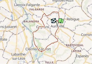
Trail Running of 14.1 km to be discovered at Occitania, Haute-Garonne, Aureville. This trail is proposed by tracegps.

Description

Circuit physique pour le runner le long de l'Ariège et de ses coteaux.

Elevation profile

Photos

Positioning

Country:
France
Region :
Occitania
Department/Province :
Haute-Garonne
Municipality :
Aureville
Location:
Unknown
Start:(UTM)
374855 ; 4815446 (31T) N.

Trails nearby

Trail Mountain bike Pins-Justaret - De Pins Justaret à Clermont Le Fort - Photo
Mountain bike
tracegps

Mountain bike

Medium
(1)
Pins-Justaret, Occitania, Haute-Garonne, France
30 km | 35 km-effort
2h 30min
Yes
Trail Mountain bike Aureville - Aureville à Goyrans - Photo
Mountain bike
tracegps

Mountain bike

Medium
(1)
Aureville, Occitania, Haute-Garonne, France
14.9 km | 19.4 km-effort
1h 0min
Yes
Trail Walking Aureville - Aureville à Goyrans - Photo
Walking
tracegps

Walking

Medium
(1)
Aureville, Occitania, Haute-Garonne, France
14.9 km | 19.4 km-effort
3h 0min
Yes
Trail On foot Clermont-le-Fort - Boucle de Notre-Dame des Bois - Photo
On foot
PRO

On foot

Easy
Clermont-le-Fort, Occitania, Haute-Garonne, France
10.9 km | 14.1 km-effort
3h 12min
Yes
Trail Other activity Corronsac - Véro - Photo
Other activity
Frings

Other activity

Very easy
(1)
Corronsac, Occitania, Haute-Garonne, France
22 km | 29 km-effort
1h 33min
Yes
Trail Walking Clermont-le-Fort - L'Ariège de Clermont Le Fort à Vénerque - Photo
Walking
tracegps

Walking

Medium
(2)
Clermont-le-Fort, Occitania, Haute-Garonne, France
9.2 km | 12.2 km-effort
2h 0min
Yes
Trail Walking Pinsaguel - PINSAGUEL : sentier de la Confluence (24.08.2023) - Photo
Walking
chrisgps

Walking

Very easy
Pinsaguel, Occitania, Haute-Garonne, France
3.8 km | 4.4 km-effort
1h 15min
Yes
Trail Walking Castanet-Tolosan - casranzt fait - Photo
Walking
pidjam

Walking

Very easy
(1)
Castanet-Tolosan, Occitania, Haute-Garonne, France
10.5 km | 12.6 km-effort
2h 26min
Yes
Trail Mountain bike Pins-Justaret - Pins justaret - Photo
Mountain bike
seb31410

Mountain bike

Easy
(1)
Pins-Justaret, Occitania, Haute-Garonne, France
34 km | 40 km-effort
2h 49min
Yes


Close
My subscriptions