Trail Running Falga - Falga - Auriac sur Vendinelle - Photo

Falga - Auriac sur Vendinelle

 tracegps
tracegps

User

© OpenStreetMap contributors
Length
Length
15 km
Max alt
Max alt
278 m
Uphill gradient
Uphill gradient
177 m
Km-Effort
Km-Effort  
17.4 km
Min alt
Min alt
189 m
Downhill gradient
Downhill gradient
178 m
Boucle
Boucle
Yes
Creation date :
2014-12-10 00:00:00.0
Updated on :
2014-12-10 00:00:00.0

(0 Reviews)

Running
Running
1h30
Difficulty : Difficult

Scan this QR Code to open this trail in the SityTrail application

FREE GPS app for hiking

Logo SityTrail SityTrail

IGN / Geographical institutes

Download SityTrail from the App Store Download SityTrail from Google Play

Logo SityTrail SityTrail World

The world is yours!

Download SityTrail from the App Store Download SityTrail from Google Play Download SityTrail on Huawei AppGallery

About

Trail Running of 15 km to be discovered at Occitania, Haute-Garonne, Falga. This trail is proposed by tracegps.

Description

Commune rurale du Lauragais, Le Falga présente un habitat dispersé. Ses 110 habitants se répartissent dans les fermes et hameaux. L'Eglise du Falga présente un très joli clocher mur. (source Mairie du Falga)

Elevation profile

Photos

Positioning

Country:
France
Region :
Occitania
Department/Province :
Haute-Garonne
Municipality :
Falga
Location:
Unknown
Start:(UTM)
407830 ; 4814552 (31T) N.

Trails nearby

Trail Walking Saint-Julia - gras capou - Photo
Walking
arnoultjf

Walking

Very difficult
Saint-Julia, Occitania, Haute-Garonne, France
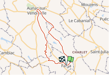
39 km | 46 km-effort
3h 18min
No
Trail On foot Vaux - circuit de la saune - Photo
On foot
PRO

On foot

Easy
Vaux, Occitania, Haute-Garonne, France
15.9 km | 19.1 km-effort
4h 20min
No
Trail Walking Saint-Félix-Lauragais - Randonnée pédestre à St-Félix-Lauragais - Photo
Walking
cappelle

Walking

Easy
Saint-Félix-Lauragais, Occitania, Haute-Garonne, France
8.8 km | 11.2 km-effort
2h 33min
Yes
Trail Walking Vaux - Le Vaux 31 - Photo
Walking
Philplaisir

Walking

Easy
Vaux, Occitania, Haute-Garonne, France
22 km | 26 km-effort
2h 17min
No
Trail Walking Saint-Félix-Lauragais - 31_Saint Félix_30km - Photo
Walking
jab31

Walking

Very difficult
Saint-Félix-Lauragais, Occitania, Haute-Garonne, France
32 km | 40 km-effort
7h 5min
Yes
Trail Walking Vaux - 25 MARS 2019 - Photo
Walking
FLOCON

Walking

Medium
Vaux, Occitania, Haute-Garonne, France
10.4 km | 13 km-effort
2h 32min
Yes
Trail Walking Saint-Julia - St-Julia - Photo
Walking
jpp2caunes

Walking

Very easy
Saint-Julia, Occitania, Haute-Garonne, France
13.4 km | 16 km-effort
5h 34min
Yes
Trail Walking Vaux - 07 MAI 2018 - Photo
Walking
FLOCON

Walking

Medium
Vaux, Occitania, Haute-Garonne, France
11.6 km | 14.6 km-effort
2h 46min
Yes
Trail Running Saint-Félix-Lauragais - Bouclé à Cadenac ! - Photo
Running
tracegps

Running

Difficult
Saint-Félix-Lauragais, Occitania, Haute-Garonne, France
14.8 km | 17.5 km-effort
1h 19min
Yes


Close
My subscriptions