


Grande Traversée du Limousin 2006 ( 2)

tracegps
User
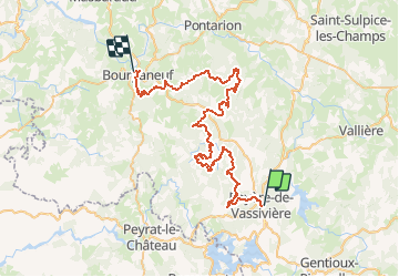

Length
59 km

Max alt
833 m

Uphill gradient
1668 m
Km-Effort
82 km

Min alt
411 m

Downhill gradient
1999 m
Boucle
No
Creation date :
2014-12-10 00:00:00.0
Updated on :
2014-12-10 00:00:00.0
4h00
Difficulty : Very difficult

FREE GPS app for hiking
 SityTrail
IGN / Geographical institutes
SityTrail Plus
The world is yours!
About
Trail Mountain bike of 59 km to be discovered at New Aquitaine, Creuse, Royère-de-Vassivière. This trail is proposed by tracegps.
Description
Deuxième étape de cette difficile épreuve.
Photos
 - Photo 1")
Positioning
Country:
France
Region :
New Aquitaine
Department/Province :
Creuse
Municipality :
Royère-de-Vassivière
Location:
Unknown
Start:(Dec)
Start:(UTM)
415683 ; 5077025 (31T) N.
Comments