Trail Mountain bike Pieusse - Los camins de la blanqueta 2006 - Photo

Los camins de la blanqueta 2006

 tracegps
tracegps

User

© OpenStreetMap contributors
Length
Length
53 km
Max alt
Max alt
587 m
Uphill gradient
Uphill gradient
1359 m
Km-Effort
Km-Effort  
71 km
Min alt
Min alt
149 m
Downhill gradient
Downhill gradient
1359 m
Boucle
Boucle
Yes
Creation date :
2014-12-10 00:00:00.0
Updated on :
2014-12-10 00:00:00.0

(0 Reviews)

Mountain bike
Mountain bike
4h30
Difficulty : Very difficult

Scan this QR Code to open this trail in the SityTrail application

FREE GPS app for hiking

Logo SityTrail SityTrail

IGN / Geographical institutes

Download SityTrail from the App Store Download SityTrail from Google Play

Logo SityTrail SityTrail World

The world is yours!

Download SityTrail from the App Store Download SityTrail from Google Play Download SityTrail on Huawei AppGallery

About

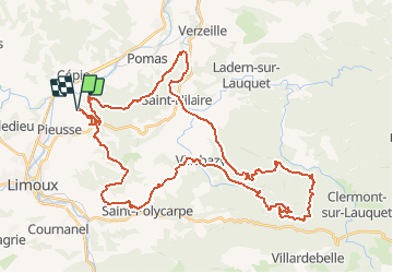
Trail Mountain bike of 53 km to be discovered at Occitania, Aude, Pieusse. This trail is proposed by tracegps.

Description

11 Juin 2006 L'an passé j'avais élu cette rando comme la meilleure de celles auxquelles j'avais participé en 2005. Forcément la barre était placée haut, et refaire aussi bien en modifiant un gros quart du parcours n'était pas évident. C'est pourtant ce qu'ont réussi à faire les VTTistes du club de Limoux, Pimaxmu en tête !..... La suite est ICI

Elevation profile

Photos

Positioning

Country:
France
Region :
Occitania
Department/Province :
Aude
Municipality :
Pieusse
Location:
Unknown
Start:(UTM)
438696 ; 4770869 (31T) N.

Trails nearby

Trail Walking Saint-Martin-de-Villereglan - rando saint Martin de villereglan - Photo
Walking
Mamilaure

Walking

Easy
(1)
Saint-Martin-de-Villereglan, Occitania, Aude, France
10.7 km | 13.5 km-effort
2h 23min
Yes
Trail Mountain bike Montclar - VTT à Arnauteille - Montclar - Photo
Mountain bike
tracegps

Mountain bike

Difficult
(3)
Montclar, Occitania, Aude, France
21 km | 28 km-effort
1h 40min
Yes
Trail Walking Limoux - Limoux- Ninaute- Mounnet - Photo
Walking
mikaou.t

Walking

Medium
(1)
Limoux, Occitania, Aude, France
10.9 km | 15.7 km-effort
3h 0min
Yes
Trail Walking Cépie - Cépié - Photo
Walking
GUIDE
Ada11

Walking

Very easy
Cépie, Occitania, Aude, France
12.9 km | 16.8 km-effort
2h 34min
Yes
Trail Walking Saint-Hilaire - Boucle de Saint-Hilaire - Photo
Walking
PI11

Walking

Medium
(1)
Saint-Hilaire, Occitania, Aude, France
8.8 km | 11.2 km-effort
2h 32min
Yes
Trail Mountain bike Limoux - Limoux, toureille, croix st Pierre   - Photo
Mountain bike
schwarzy

Mountain bike

Difficult
Limoux, Occitania, Aude, France
30 km | 42 km-effort
4h 41min
Yes
Trail Mountain bike Pieusse - Los camins de la blanqueta (prox. Limoux) - Photo
Mountain bike
tracegps

Mountain bike

Very difficult
Pieusse, Occitania, Aude, France
53 km | 72 km-effort
6h 0min
Yes
Trail On foot Villar-Saint-Anselme - Tour du Bois des Bruyères - Photo
On foot
PRO

On foot

Easy
Villar-Saint-Anselme, Occitania, Aude, France
5.1 km | 7.2 km-effort
1h 38min
Yes
Trail Walking Saint-Hilaire - saint hilaire 30-09-2019 - Photo
Walking
mouma_77

Walking

Very easy
Saint-Hilaire, Occitania, Aude, France
9.1 km | 11.5 km-effort
3h 29min
Yes


Close
My subscriptions