Trail Walking Saint-Martin-de-Villereglan - rando saint Martin de villereglan - Photo

rando saint Martin de villereglan

© OpenStreetMap contributors
Length
Length
10.7 km
Max alt
Max alt
309 m
Uphill gradient
Uphill gradient
205 m
Km-Effort
Km-Effort  
13.5 km
Min alt
Min alt
177 m
Downhill gradient
Downhill gradient
206 m
Boucle
Boucle
Yes
Creation date :
2023-02-24 08:15:33.933
Updated on :
2023-03-04 15:44:58.671

(1 Reviews)

Walking
Walking
2h23
Difficulty : Easy

Scan this QR Code to open this trail in the SityTrail application

FREE GPS app for hiking

Logo SityTrail SityTrail

IGN / Geographical institutes

Download SityTrail from the App Store Download SityTrail from Google Play

Logo SityTrail SityTrail World

The world is yours!

Download SityTrail from the App Store Download SityTrail from Google Play Download SityTrail on Huawei AppGallery

About

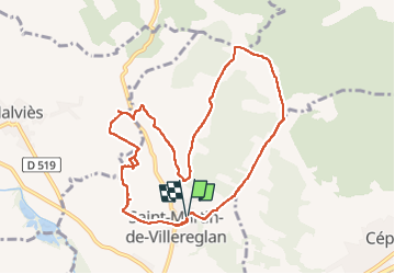
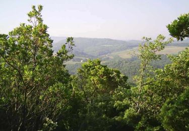
Trail Walking of 10.7 km to be discovered at Occitania, Aude, Saint-Martin-de-Villereglan. This trail is proposed by Mamilaure.

Description

Se garer au parking fléché conseillé en entrant au village
le départ de la rando se fait en montant sur la droite du parking
Balisage jaune assez précis sauf vers la fin pour la traversée des dernières vignes avant d'arrivée à la Notre Dame du Razes

Elevation profile

Photos

Positioning

Country:
France
Region :
Occitania
Department/Province :
Aude
Municipality :
Saint-Martin-de-Villereglan
Location:
Unknown
Start:(UTM)
435907 ; 4773034 (31T) N.

Comments

Please log in to post a review or rate the element


Trails nearby

Trail Mountain bike Montclar - VTT à Arnauteille - Montclar - Photo
Mountain bike
tracegps

Mountain bike

Difficult
(3)
Montclar, Occitania, Aude, France
21 km | 28 km-effort
1h 40min
Yes
Trail Walking Cépie - Cépié - Photo
Walking
GUIDE
Ada11

Walking

Very easy
Cépie, Occitania, Aude, France
12.9 km | 16.8 km-effort
2h 34min
Yes
Trail Walking Routier - Lauraguel  - Photo
Walking
Christophe Ferreres

Walking

Medium
Routier, Occitania, Aude, France
9.7 km | 11.1 km-effort
2h 19min
No
Trail Mountain bike Limoux - Limoux, toureille, croix st Pierre   - Photo
Mountain bike
schwarzy

Mountain bike

Difficult
Limoux, Occitania, Aude, France
30 km | 42 km-effort
4h 41min
Yes
Trail Walking Villarzel-du-Razès - Rec Grand - Villarzel du Razès - Photo
Walking
Taricot

Walking

Medium
Villarzel-du-Razès, Occitania, Aude, France
9.5 km | 12.6 km-effort
3h 0min
Yes
Trail Walking Villarzel-du-Razès - Rec Grand - Villarzel du Razès - Photo
Walking
tracegps

Walking

Medium
(1)
Villarzel-du-Razès, Occitania, Aude, France
9.5 km | 12.6 km-effort
3h 0min
Yes
Trail Mountain bike Pieusse - Los camins de la blanqueta 2006 - Photo
Mountain bike
tracegps

Mountain bike

Very difficult
Pieusse, Occitania, Aude, France
53 km | 71 km-effort
4h 30min
Yes
Trail Mountain bike Pieusse - Los camins de la blanqueta (prox. Limoux) - Photo
Mountain bike
tracegps

Mountain bike

Very difficult
Pieusse, Occitania, Aude, France
53 km | 72 km-effort
6h 0min
Yes
Trail Walking Pauligne - pauligne, Cassagnau, Le Soulié, Pauligne - Photo
Walking
christinetondeur

Walking

Easy
Pauligne, Occitania, Aude, France
9.5 km | 12.1 km-effort
2h 39min
Yes


Close
My subscriptions