


Lac de la Tuile

choubaka77
User
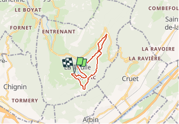

Length
9.5 km

Max alt
1059 m

Uphill gradient
385 m
Km-Effort
14.6 km

Min alt
873 m

Downhill gradient
386 m
Boucle
Yes
Creation date :
2019-01-15 13:33:08.49
Updated on :
2019-01-15 13:33:08.49
1h30
Difficulty : Medium

FREE GPS app for hiking
 SityTrail
IGN / Geographical institutes
SityTrail Plus
The world is yours!
About
Trail Running of 9.5 km to be discovered at Auvergne-Rhône-Alpes, Savoy, La Thuile. This trail is proposed by choubaka77.
Positioning
Country:
France
Region :
Auvergne-Rhône-Alpes
Department/Province :
Savoy
Municipality :
La Thuile
Location:
Unknown
Start:(Dec)
Start:(UTM)
269889 ; 5046080 (32T) N.
Comments