Trail Mountain bike Saint-Arnoult-en-Yvelines - Randonnée du Bon Saint Arnoult - Photo

Randonnée du Bon Saint Arnoult

 tracegps
tracegps

User

© OpenStreetMap contributors
Length
Length
75 km
Max alt
Max alt
181 m
Uphill gradient
Uphill gradient
1351 m
Km-Effort
Km-Effort  
93 km
Min alt
Min alt
81 m
Downhill gradient
Downhill gradient
1354 m
Boucle
Boucle
Yes
Creation date :
2014-12-10 00:00:00.0
Updated on :
2014-12-10 00:00:00.0

(0 Reviews)

Mountain bike
Mountain bike
4h49
Difficulty : Very difficult

Scan this QR Code to open this trail in the SityTrail application

FREE GPS app for hiking

Logo SityTrail SityTrail

IGN / Geographical institutes

Download SityTrail from the App Store Download SityTrail from Google Play

Logo SityTrail SityTrail World

The world is yours!

Download SityTrail from the App Store Download SityTrail from Google Play Download SityTrail on Huawei AppGallery

About

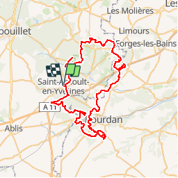
Trail Mountain bike of 75 km to be discovered at Ile-de-France, Yvelines, Saint-Arnoult-en-Yvelines. This trail is proposed by tracegps.

Description

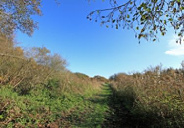
17 Sept 2006 Après 1,6km en zone urbaine, on commence à monter doucement vers la forêt en suivant le GR1. Suit une descente rapide sur terrain sablonneux, menant au Carrefour du Pendu. En face de moi un bonhomme occupe une bonne partie du chemin, à ce moment je crois que c'est un des gars de l'organisation qui est là pour nous indiquer de partir à gauche, j'oblique dans cette direction. On roule ensuite durant 1,3km sur un single sympa passant entre les fougères et des ronces fauchées, pour déboucher sur la route D132. La suite est ICI

Elevation profile

Photos

Positioning

Country:
France
Region :
Ile-de-France
Department/Province :
Yvelines
Municipality :
Saint-Arnoult-en-Yvelines
Location:
Unknown
Start:(UTM)
421555 ; 5380517 (31U) N.

Trails nearby

Trail Walking Longvilliers - _Les Moulins de la Rémarde - Photo
Walking
GUIDE+

Walking

Easy
(7)
Longvilliers, Ile-de-France, Yvelines, France
9.3 km | 10.4 km-effort
2h 0min
Yes
Trail Walking Clairefontaine-en-Yvelines - _Aux sources de la Rabette - Photo
Walking
GUIDE+

Walking

Easy
(15)
Clairefontaine-en-Yvelines, Ile-de-France, Yvelines, France
7.2 km | 8.3 km-effort
1h 51min
Yes
Trail On foot Dourdan - Promenade de Nemours - Photo
On foot
PRO

On foot

Easy
Dourdan, Ile-de-France, Essonne, France
4.5 km | 4.9 km-effort
1h 6min
No
Trail Walking Sonchamp - _Sonchamp, entre ruelles, étang et forêt - Photo
Walking
GUIDE+

Walking

Medium
Sonchamp, Ile-de-France, Yvelines, France
8.9 km | 10.1 km-effort
2h 30min
Yes
Trail Walking Sonchamp - _La marlotterie - Photo
Walking
GUIDE+

Walking

Easy
Sonchamp, Ile-de-France, Yvelines, France
5.9 km | 6.8 km-effort
1h 30min
Yes
Trail Walking Sonchamp - Sonchamps-Lorieux - Photo
Walking
raivavae

Walking

Difficult
(1)
Sonchamp, Ile-de-France, Yvelines, France
11 km | 12.5 km-effort
2h 45min
Yes
Trail Nordic walking Dourdan - Forêt de Saint Arnoult - Photo
Nordic walking
Zygomat

Nordic walking

Easy
(1)
Dourdan, Ile-de-France, Essonne, France
8.6 km | 10.5 km-effort
1h 50min
Yes
Trail Walking Dourdan - Ste Mesme St Martin de Brethencourt - Photo
Walking
raivavae

Walking

Medium
(2)
Dourdan, Ile-de-France, Essonne, France
14.9 km | 17.5 km-effort
5min
Yes
Trail Walking Dourdan - R2-Dourdan et sa forêt - Photo
Walking
CSR-94

Walking

Very difficult
(1)
Dourdan, Ile-de-France, Essonne, France
19.3 km | 24 km-effort
5h 23min
Yes


Close
My subscriptions