Trail Mountain bike Saint-Étienne-du-Valdonnez - La Fage  - Lalo - Photo
 tracegps
tracegps

User

© OpenStreetMap contributors
Length
Length
64 km
Max alt
Max alt
1211 m
Uphill gradient
Uphill gradient
1285 m
Km-Effort
Km-Effort  
82 km
Min alt
Min alt
514 m
Downhill gradient
Downhill gradient
1708 m
Boucle
Boucle
No
Creation date :
2014-12-10 00:00:00.0
Updated on :
2014-12-10 00:00:00.0

(0 Reviews)

Mountain bike
Mountain bike
4h30
Difficulty : Very difficult

Scan this QR Code to open this trail in the SityTrail application

FREE GPS app for hiking

Logo SityTrail SityTrail

IGN / Geographical institutes

Download SityTrail from the App Store Download SityTrail from Google Play

Logo SityTrail SityTrail World

The world is yours!

Download SityTrail from the App Store Download SityTrail from Google Play Download SityTrail on Huawei AppGallery

About

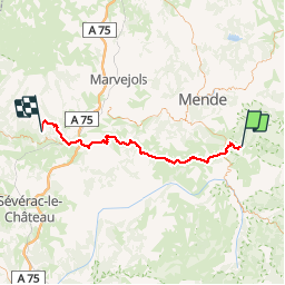
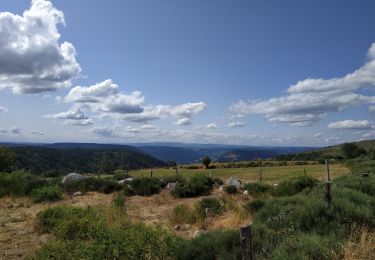
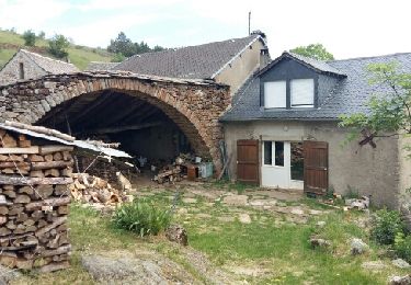
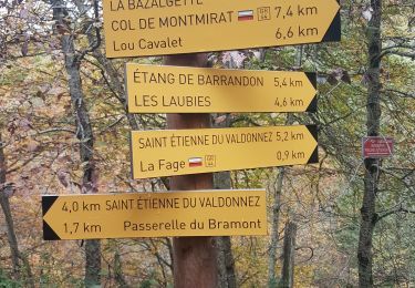
Trail Mountain bike of 64 km to be discovered at Occitania, Lozère, Saint-Étienne-du-Valdonnez. This trail is proposed by tracegps.

Description

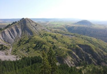
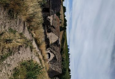
28 Mai 2005 5ème et dernière étape de Valence - Lalo C'est également l'étape la plus facile et la plus courte.. Le causse Sauveterre est avalé assez vite. Le passage de Les fonts à La Canourgue est superbe. La montée de Lescure à Lalo est la seule difficulté de l'étape. La suite du récit et des photos, c'est ICI

Elevation profile

Photos

Positioning

Country:
France
Region :
Occitania
Department/Province :
Lozère
Municipality :
Saint-Étienne-du-Valdonnez
Location:
Unknown
Start:(UTM)
547333 ; 4920149 (31T) N.

Trails nearby

Trail On foot Saint-Étienne-du-Valdonnez - Balade au pays des menhirs - Photo
On foot
PRO

On foot

Easy
Saint-Étienne-du-Valdonnez, Occitania, Lozère, France
5.5 km | 8 km-effort
1h 48min
Yes
Trail Walking Saint-Étienne-du-Valdonnez - Gorges du Bramont - Photo
Walking
GUIDE
nadinebondoux

Walking

Easy
Saint-Étienne-du-Valdonnez, Occitania, Lozère, France
13.2 km | 18.8 km-effort
4h 38min
Yes
Trail Walking Saint-Étienne-du-Valdonnez - les gorges du Bramont - Photo
Walking
herve.feurprier

Walking

Easy
(1)
Saint-Étienne-du-Valdonnez, Occitania, Lozère, France
8 km | 11.8 km-effort
2h 52min
Yes
Trail Walking Les Bondons - les deux monts verts - Photo
Walking
lablaquiere

Walking

Medium
Les Bondons, Occitania, Lozère, France
6.8 km | 9.6 km-effort
2h 31min
Yes
Trail Walking Les Bondons - malbosc - Photo
Walking
verreetsable

Walking

Medium
Les Bondons, Occitania, Lozère, France
26 km | 37 km-effort
4h 32min
No
Trail Electric bike Saint-Étienne-du-Valdonnez - les laubies à st etienne du valdonnez - Photo
Electric bike
herve.feurprier

Electric bike

Easy
Saint-Étienne-du-Valdonnez, Occitania, Lozère, France
34 km | 46 km-effort
4h 0min
Yes
Trail Walking Saint-Étienne-du-Valdonnez - Tour Lozère étape 3 - Photo
Walking
cmaymard

Walking

Very easy
Saint-Étienne-du-Valdonnez, Occitania, Lozère, France
17.1 km | 23 km-effort
5h 35min
No
Trail Walking Saint-Étienne-du-Valdonnez - gorges du Bramont - Photo
Walking
thomas.o.vert

Walking

Medium
Saint-Étienne-du-Valdonnez, Occitania, Lozère, France
10 km | 14.8 km-effort
3h 40min
Yes
Trail Equestrian Saint-Étienne-du-Valdonnez - 2018-05-26 Rando CVA La Fage vers Florac Reel - Photo
Equestrian
GUIDE
holtzv

Equestrian

Very easy
Saint-Étienne-du-Valdonnez, Occitania, Lozère, France
35 km | 46 km-effort
5h 25min
No


Close
My subscriptions