Trail Mountain bike Barr - Circuit des 3 Petits Ponts - Photo

Circuit des 3 Petits Ponts

 tracegps
tracegps

User

© OpenStreetMap contributors
Length
Length
15.9 km
Max alt
Max alt
834 m
Uphill gradient
Uphill gradient
424 m
Km-Effort
Km-Effort  
22 km
Min alt
Min alt
672 m
Downhill gradient
Downhill gradient
424 m
Boucle
Boucle
Yes
Creation date :
2014-12-10 00:00:00.0
Updated on :
2014-12-10 00:00:00.0

(1 Reviews)

Mountain bike
Mountain bike
1h19
Difficulty : Difficult

Scan this QR Code to open this trail in the SityTrail application

FREE GPS app for hiking

Logo SityTrail SityTrail

IGN / Geographical institutes

Download SityTrail from the App Store Download SityTrail from Google Play

Logo SityTrail SityTrail World

The world is yours!

Download SityTrail from the App Store Download SityTrail from Google Play Download SityTrail on Huawei AppGallery

About

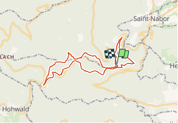
Trail Mountain bike of 15.9 km to be discovered at Grand Est, Bas-Rhin, Barr. This trail is proposed by tracegps.

Description

Démarrez le circuit au carrefour des routes D526 et D854. Vous y trouverez un parking et les premières difficultés seront les pires. Suivez le ©GR5 vers le kiosque Jadelot. Après 200m , bifurquez sur votre gauche et retrouvez le ©GR5 jusqu'à l'abri du Maennelstein. La montée est un peu raide mais sans difficultés techniques. De l'abri , poursuivez sur le GR5 jusqu'à croiser le sentier rond bleu sur votre gauche . La suite est ICI Source: Pierre

Elevation profile

Photos

Positioning

Country:
France
Region :
Grand Est
Department/Province :
Bas-Rhin
Municipality :
Barr
Location:
Unknown
Start:(UTM)
381648 ; 5364717 (32U) N.

Comments

Please log in to post a review or rate the element


Très sympa pour passer un bon moment de début de saison merci


Trails nearby

Trail Walking Ottrott - Le circuit sud du Mur Païen - Photo
Walking
VacheKiri67

Walking

Easy
(2)
Ottrott, Grand Est, Bas-Rhin, France
4.9 km | 6.3 km-effort
1h 56min
No
Trail Walking Ottrott - Le circuit nord du Mur Païen - Photo
Walking
VacheKiri67

Walking

Easy
(1)
Ottrott, Grand Est, Bas-Rhin, France
5.9 km | 8.5 km-effort
2h 4min
No
Trail Walking Ottrott - Le Mont Sainte-Odile depuis Otrott - Photo
Walking
VacheKiri67

Walking

Medium
(1)
Ottrott, Grand Est, Bas-Rhin, France
13 km | 20 km-effort
6h 18min
Yes
Trail Walking Ottrott - Montée vers le Mont Sainte-Odile - Photo
Walking
VacheKiri67

Walking

Difficult
(1)
Ottrott, Grand Est, Bas-Rhin, France
17.6 km | 26 km-effort
5h 52min
Yes
Trail Walking Andlau - Depuis Andlau vers le village viticole de Mittelbergheim - Photo
Walking
VacheKiri67

Walking

Medium
(1)
Andlau, Grand Est, Bas-Rhin, France
11.9 km | 15.9 km-effort
4h 3min
Yes
Trail Walking Ottrott - Le mur païen - Photo
Walking
VacheKiri67

Walking

Medium
(4)
Ottrott, Grand Est, Bas-Rhin, France
10.5 km | 14.5 km-effort
4h 36min
Yes
Trail Walking Ottrott - Mur Paien complet - Photo
Walking
markrei

Walking

Medium
(1)
Ottrott, Grand Est, Bas-Rhin, France
12 km | 16.4 km-effort
5h 25min
Yes
Trail Mountain bike Ottrott - Sainte-Odile East-Face - Photo
Mountain bike
tracegps

Mountain bike

Difficult
(1)
Ottrott, Grand Est, Bas-Rhin, France
24 km | 39 km-effort
3h 0min
Yes
Trail Walking Obernai - sentier des merveilles - Photo
Walking
semila

Walking

Difficult
(1)
Obernai, Grand Est, Bas-Rhin, France
11 km | 16.6 km-effort
4h 8min
Yes


Close
My subscriptions