


73Va/Mottets/Pointe_Cerces/Mottets

trietsch
User
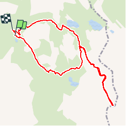

Length
10.7 km

Max alt
3071 m

Uphill gradient
955 m
Km-Effort
23 km

Min alt
2145 m

Downhill gradient
938 m
Boucle
Yes
Creation date :
2019-01-15 13:57:50.448
Updated on :
2020-01-04 20:28:43.659
4h35
Difficulty : Unknown

FREE GPS app for hiking
 SityTrail
IGN / Geographical institutes
SityTrail Plus
The world is yours!
About
Trail Walking of 10.7 km to be discovered at Auvergne-Rhône-Alpes, Savoy, Valloire. This trail is proposed by trietsch.
Positioning
Country:
France
Region :
Auvergne-Rhône-Alpes
Department/Province :
Savoy
Municipality :
Valloire
Location:
Unknown
Start:(Dec)
Start:(UTM)
299623 ; 4995300 (32T) N.
Comments