


73Va Refuge_terres_rouges/

trietsch
User
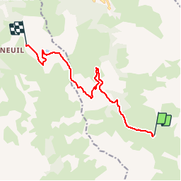

Length
11.1 km

Max alt
2495 m

Uphill gradient
673 m
Km-Effort
20 km

Min alt
1927 m

Downhill gradient
752 m
Boucle
No
Creation date :
2019-01-15 13:59:03.372
Updated on :
2020-01-04 20:28:39.764
4h03
Difficulty : Unknown

FREE GPS app for hiking
 SityTrail
IGN / Geographical institutes
SityTrail Plus
The world is yours!
About
Trail Walking of 11.1 km to be discovered at Auvergne-Rhône-Alpes, Savoy, Valmeinier. This trail is proposed by trietsch.
Positioning
Country:
France
Region :
Auvergne-Rhône-Alpes
Department/Province :
Savoy
Municipality :
Valmeinier
Location:
Unknown
Start:(Dec)
Start:(UTM)
304528 ; 5000504 (32T) N.
Comments