Trail Mountain bike Bourg-Argental - Pilat par la face sud - Photo
 tracegps
tracegps

User

© OpenStreetMap contributors
Length
Length
34 km
Max alt
Max alt
1324 m
Uphill gradient
Uphill gradient
1179 m
Km-Effort
Km-Effort  
50 km
Min alt
Min alt
501 m
Downhill gradient
Downhill gradient
1179 m
Boucle
Boucle
Yes
Creation date :
2014-12-10 00:00:00.0
Updated on :
2014-12-10 00:00:00.0

(1 Reviews)

Mountain bike
Mountain bike
4h30
Difficulty : Difficult

Scan this QR Code to open this trail in the SityTrail application

FREE GPS app for hiking

Logo SityTrail SityTrail

IGN / Geographical institutes

Download SityTrail from the App Store Download SityTrail from Google Play

Logo SityTrail SityTrail World

The world is yours!

Download SityTrail from the App Store Download SityTrail from Google Play Download SityTrail on Huawei AppGallery

About

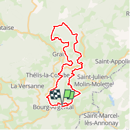
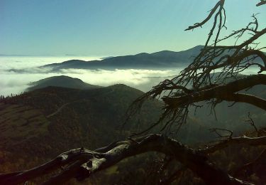
Trail Mountain bike of 34 km to be discovered at Auvergne-Rhône-Alpes, Loire, Bourg-Argental. This trail is proposed by tracegps.

Description

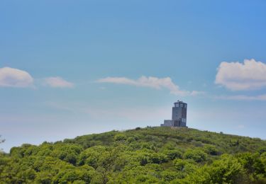
Circuit physique mais permet d'atteindre en VTT le haut du Pilat sans mettre pied à terre, ddesccente rapide par des petits sentiers, pas de goudron , pas de portage ni poussage

Elevation profile

Positioning

Country:
France
Region :
Auvergne-Rhône-Alpes
Department/Province :
Loire
Municipality :
Bourg-Argental
Location:
Unknown
Start:(UTM)
623388 ; 5017338 (31T) N.

Comments

Please log in to post a review or rate the element


Trails nearby

Trail On foot Bourg-Argental - Pilat Nº2: Bourg-Argental - Le Grand Bois - Photo
On foot
PRO

On foot

Difficult
Bourg-Argental, Auvergne-Rhône-Alpes, Loire, France
22 km | 33 km-effort
7h 30min
Yes
Trail Walking Bourg-Argental - Bourg Argental 2013 - Photo
Walking
tracegps

Walking

Medium
Bourg-Argental, Auvergne-Rhône-Alpes, Loire, France
22 km | 34 km-effort
6h 30min
Yes
Trail Other activity Burdignes - croix de Chirol - Photo
Other activity
bpc

Other activity

Very easy
Burdignes, Auvergne-Rhône-Alpes, Loire, France
18.4 km | 27 km-effort
4h 55min
Yes
Trail Walking Burdignes - croix de chirol - Photo
Walking
bpc

Walking

Medium
Burdignes, Auvergne-Rhône-Alpes, Loire, France
18.4 km | 27 km-effort
5h 38min
Yes
Trail Walking Burdignes - Burdignes - Croix de  Chirol - Photo
Walking
tracegps

Walking

Medium
Burdignes, Auvergne-Rhône-Alpes, Loire, France
9.7 km | 13.7 km-effort
2h 30min
Yes
Trail Walking Saint-Marcel-lès-Annonay - St Marcel les Annonay/ la croix des Blaches - Photo
Walking
tartane1

Walking

Medium
Saint-Marcel-lès-Annonay, Auvergne-Rhône-Alpes, Ardèche, France
5.7 km | 8.2 km-effort
1h 51min
Yes
Trail Walking Colombier - colombier 2 - Photo
Walking
JamesVautier

Walking

Easy
Colombier, Auvergne-Rhône-Alpes, Loire, France
10.6 km | 16.2 km-effort
3h 19min
Yes
Trail Walking Colombier - Colombier  - Photo
Walking
Gilles Mialon

Walking

Difficult
Colombier, Auvergne-Rhône-Alpes, Loire, France
8 km | 17.2 km-effort
6h 27min
No
Trail Nordic walking La Versanne - boucle la versanne  - Photo
Nordic walking
Patrick Savaglio

Nordic walking

Very easy
La Versanne, Auvergne-Rhône-Alpes, Loire, France
10.4 km | 16 km-effort
2h 21min
Yes


Close
My subscriptions