


2018 08 09 Soultzmatt - Caveau Orschwihr

E.BURCK
User
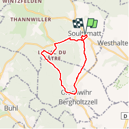

Length
10.3 km

Max alt
444 m

Uphill gradient
271 m
Km-Effort
13.9 km

Min alt
250 m

Downhill gradient
270 m
Boucle
Yes
Creation date :
2019-05-22 16:12:00.771
Updated on :
2019-05-22 16:12:00.807
--
Difficulty : Easy

FREE GPS app for hiking
 SityTrail
IGN / Geographical institutes
SityTrail Plus
The world is yours!
About
Trail Walking of 10.3 km to be discovered at Grand Est, Haut-Rhin, Soultzmatt. This trail is proposed by E.BURCK.
Description
Dénivelé de 251 m sur 10.3 km.STATIONNEMENT : - parking près de la mairie de Soultzmatt. 47.961540, 7.239279 ou N 47°57'41", E 7°14'21" RESTAURATION: Caveau d'OrschwihrTél: 03 89 76 90 31
Positioning
Country:
France
Region :
Grand Est
Department/Province :
Haut-Rhin
Municipality :
Soultzmatt
Location:
Unknown
Start:(Dec)
Start:(UTM)
368569 ; 5313517 (32T) N.
Comments