Trail Mountain bike Bréziers - Espace VTT FFC de Serre-Ponçon - Durance - Circuit n°13 - Les Garcinets - Photo

Espace VTT FFC de Serre-Ponçon - Durance - Circuit n°13 - Les Garcinets

 tracegps
tracegps

User

© OpenStreetMap contributors
Length
Length
20 km
Max alt
Max alt
1287 m
Uphill gradient
Uphill gradient
729 m
Km-Effort
Km-Effort  
30 km
Min alt
Min alt
854 m
Downhill gradient
Downhill gradient
730 m
Boucle
Boucle
Yes
Creation date :
2014-12-10 00:00:00.0
Updated on :
2014-12-10 00:00:00.0

(0 Reviews)

Mountain bike
Mountain bike
2h00
Difficulty : Difficult

Scan this QR Code to open this trail in the SityTrail application

FREE GPS app for hiking

Logo SityTrail SityTrail

IGN / Geographical institutes

Download SityTrail from the App Store Download SityTrail from Google Play

Logo SityTrail SityTrail World

The world is yours!

Download SityTrail from the App Store Download SityTrail from Google Play Download SityTrail on Huawei AppGallery

About

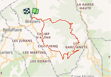
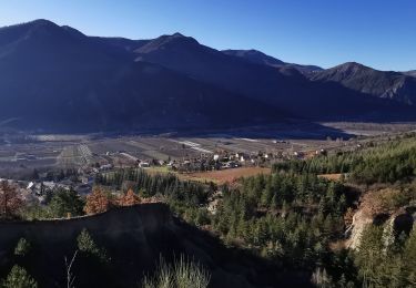
Trail Mountain bike of 20 km to be discovered at Provence-Alpes-Côte d'Azur, Hautes-Alpes, Bréziers. This trail is proposed by tracegps.

Description

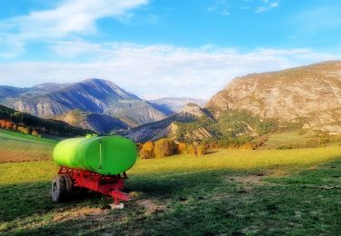
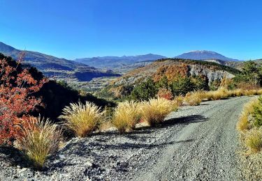
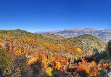
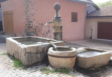
Espace VTT FFC de Serre-Ponçon - Durance Circuit labellisé par la Fédération Française de Cyclisme. Départ à l’entrée de Bréziers (parking du bas). Montée soutenue sur 4 km environ sur piste forestière roulante jusqu’au col à 1281 m d’altitude. Descente sur piste sans difficulté technique jusqu’aux Garcinets puis retour sur route goudronnée jusqu’à Bréziers. Liaison possible avec le circuit n°12 et Rochebrune par descente sur route goudronnée. Circuit en boucle autour de la montagne de Seymuit pour la première partie puis champêtre en fin de parcours. Le village de Bréziers datant du XVII-XVIII ème siècle adossé à un piton rocheux. Le vieux hameau agricole des Garcinets.

Elevation profile

Photos

Positioning

Country:
France
Region :
Provence-Alpes-Côte d'Azur
Department/Province :
Hautes-Alpes
Municipality :
Bréziers
Location:
Unknown
Start:(UTM)
276982 ; 4923288 (32T) N.

Trails nearby

Trail Walking Rochebrune - Chapelle Saint-Sixte Via Rochebrune - Photo
Walking
PapouBertrand

Walking

Medium
(1)
Rochebrune, Provence-Alpes-Côte d'Azur, Hautes-Alpes, France
3.9 km | 7.4 km-effort
1h 52min
Yes
Trail Walking Turriers - Turriers - Très Pébès - Photo
Walking
GUIDE
R@ph

Walking

Easy
Turriers, Provence-Alpes-Côte d'Azur, Alpes-de-Haute-Provence, France
5 km | 7 km-effort
1h 34min
Yes
Trail Walking Turriers - Grande Gautière - Photo
Walking
GUIDE
R@ph

Walking

Medium
(1)
Turriers, Provence-Alpes-Côte d'Azur, Alpes-de-Haute-Provence, France
12.5 km | 27 km-effort
5h 21min
Yes
Trail Walking Gigors - sabots de venus gigors 860m 12kms - Photo
Walking
GUIDE
Danielba

Walking

Difficult
Gigors, Provence-Alpes-Côte d'Azur, Alpes-de-Haute-Provence, France
10.8 km | 21 km-effort
6h 40min
Yes
Trail Electric bike Remollon - Le Puy et la Chapelle Saint-Sixte Via Remollon (Vélo) - Photo
Electric bike
PapouBertrand

Electric bike

Difficult
Remollon, Provence-Alpes-Côte d'Azur, Hautes-Alpes, France
23 km | 31 km-effort
2h 7min
Yes
Trail Electric bike Remollon - VTT-ae - Mont Colombis via Valserres - Croix des prés - Photo
Electric bike
PapouBertrand

Electric bike

Difficult
Remollon, Provence-Alpes-Côte d'Azur, Hautes-Alpes, France
38 km | 58 km-effort
4h 56min
Yes
Trail Mountain bike Remollon - VTT-ae - La Croix des Prés avec V&H - Photo
Mountain bike
PapouBertrand

Mountain bike

Very difficult
Remollon, Provence-Alpes-Côte d'Azur, Hautes-Alpes, France
45 km | 64 km-effort
4h 45min
Yes
Trail Walking Gigors - GIGORS Cretes des Barses par variante n - Photo
Walking
RobinMicheline

Walking

Difficult
Gigors, Provence-Alpes-Côte d'Azur, Alpes-de-Haute-Provence, France
13.8 km | 24 km-effort
4h 46min
Yes
Trail Walking Remollon - Le Balcon de Remollon - Photo
Walking
PapouBertrand

Walking

Difficult
Remollon, Provence-Alpes-Côte d'Azur, Hautes-Alpes, France
8.4 km | 15.5 km-effort
3h 31min
Yes


Close
My subscriptions