


Poupehan-Rochehaut

alain51370
User
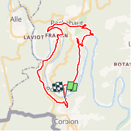

Length
14.9 km

Max alt
369 m

Uphill gradient
634 m
Km-Effort
23 km

Min alt
194 m

Downhill gradient
618 m
Boucle
Yes
Creation date :
2018-08-16 15:13:59.465
Updated on :
2018-08-16 15:13:59.548
4h49
Difficulty : Medium

FREE GPS app for hiking
 SityTrail
IGN / Geographical institutes
SityTrail Plus
The world is yours!
About
Trail Walking of 14.9 km to be discovered at Wallonia, Luxembourg, Bouillon. This trail is proposed by alain51370.
Points of interest


Positioning
Country:
Belgium
Region :
Wallonia
Department/Province :
Luxembourg
Municipality :
Bouillon
Location:
Poupehan
Start:(Dec)
Start:(UTM)
644333 ; 5519201 (31U) N.
Comments