


geishouse abri faucon crecerelle_wpt_tr

JCLUTT
User
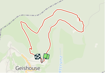

Length
5.1 km

Max alt
1026 m

Uphill gradient
261 m
Km-Effort
8.6 km

Min alt
753 m

Downhill gradient
263 m
Boucle
Yes
Creation date :
2019-05-21 17:17:04.532
Updated on :
2021-05-26 12:26:25.845
--
Difficulty : Easy

FREE GPS app for hiking
 SityTrail
IGN / Geographical institutes
SityTrail Plus
The world is yours!
About
Trail Walking of 5.1 km to be discovered at Grand Est, Haut-Rhin, Geishouse. This trail is proposed by JCLUTT.


Positioning
Country:
France
Region :
Grand Est
Department/Province :
Haut-Rhin
Municipality :
Geishouse
Location:
Unknown
Start:(Dec)
Start:(UTM)
355316 ; 5305270 (32T) N.
Comments