


Vignobles Cuqueron G4

LouisROGER
User GUIDE
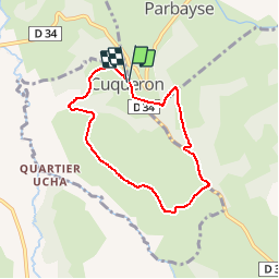

Length
6.5 km

Max alt
294 m

Uphill gradient
210 m
Km-Effort
9.3 km

Min alt
167 m

Downhill gradient
211 m
Boucle
Yes
Creation date :
2019-01-15 15:05:34.139
Updated on :
2019-01-15 15:05:34.139
1h57
Difficulty : Easy

FREE GPS app for hiking
 SityTrail
IGN / Geographical institutes
SityTrail Plus
The world is yours!
About
Trail Walking of 6.5 km to be discovered at New Aquitaine, Pyrénées-Atlantiques, Cuqueron. This trail is proposed by LouisROGER.
Description
G4 LPC
Positioning
Country:
France
Region :
New Aquitaine
Department/Province :
Pyrénées-Atlantiques
Municipality :
Cuqueron
Location:
Unknown
Start:(Dec)
Start:(UTM)
698537 ; 4799052 (30T) N.
Comments